|
|
|||||||||||||||||
| Point ID: 8699 | Downloads | Plots | Site Data | Code: 11627 |
|
|
|||||||||||||||||
| Download | |
|---|---|
| Site Descriptor Information | Site Time Series Data |
| Link to all available data | |
|
|
| View: | Statistics | Time Series |
| Units: | m3/s |
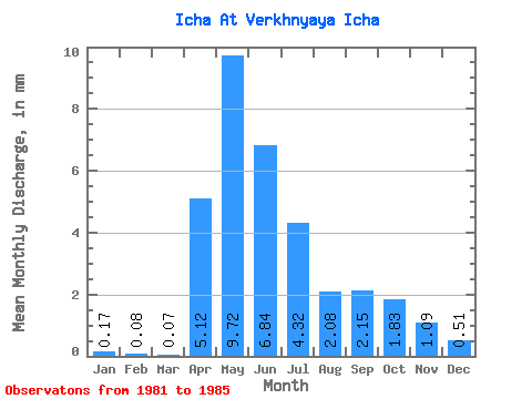
| Statistic | Jan | Feb | Mar | Apr | May | Jun | Jul | Aug | Sep | Oct | Nov | Dec | Annual |
|---|---|---|---|---|---|---|---|---|---|---|---|---|---|
| Mean | 0.17 | 0.08 | 0.07 | 5.12 | 9.72 | 6.84 | 4.32 | 2.08 | 2.15 | 1.83 | 1.09 | 0.51 | 35.52 |
| Standard Deviation | 0.20 | 0.10 | 0.11 | 4.20 | 10.84 | 9.90 | 5.36 | 2.90 | 3.59 | 2.59 | 1.57 | 0.61 | 42.57 |
| Min | 0.04 | 0.00 | 0.00 | 2.87 | 1.31 | 0.49 | 0.34 | 0.18 | 0.12 | 0.15 | 0.01 | 0.05 | 5.74 |
| Max | 0.48 | 0.22 | 0.23 | 11.42 | 25.39 | 21.50 | 11.70 | 6.94 | 8.48 | 6.24 | 3.74 | 1.50 | 97.58 |
| Coefficient of Variation | 1.18 | 1.20 | 1.53 | 0.82 | 1.11 | 1.45 | 1.24 | 1.39 | 1.67 | 1.42 | 1.44 | 1.20 | 1.20 |
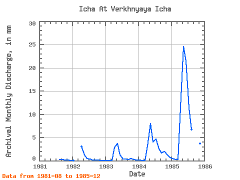
| Year | Jan | Feb | Mar | Apr | May | Jun | Jul | Aug | Sep | Oct | Nov | Dec | Annual | 1981 | 0.33 | 0.24 | 0.22 | 0.15 | 0.10 | 1982 | 0.04 | 0.00 | 0.00 | 3.02 | 1.31 | 0.49 | 0.34 | 0.18 | 0.12 | 0.15 | 0.01 | 0.05 | 5.74 | 1983 | 0.06 | 0.04 | 0.02 | 2.87 | 3.88 | 1.29 | 0.37 | 0.34 | 0.27 | 0.48 | 0.24 | 0.18 | 10.00 | 1984 | 0.12 | 0.05 | 0.03 | 3.17 | 8.30 | 4.07 | 4.85 | 2.62 | 1.62 | 2.05 | 1.32 | 0.73 | 28.77 | 1985 | 0.48 | 0.22 | 0.23 | 11.42 | 25.39 | 21.50 | 11.70 | 6.94 | 8.48 | 6.24 | 3.74 | 1.50 | 97.58 |
|---|
 Return to R-Arctic Net Home Page