|
|
|||||||||||||||||
| Point ID: 869 | Downloads | Plots | Site Data | Code: 07EE005 |
|
|
|||||||||||||||||
| Download | |
|---|---|
| Site Descriptor Information | Site Time Series Data |
| Link to all available data | |
|
|
| View: | Statistics | Time Series |
| Units: | m3/s |
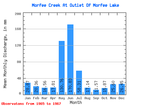
| Statistic | Jan | Feb | Mar | Apr | May | Jun | Jul | Aug | Sep | Oct | Nov | Dec | Annual |
|---|---|---|---|---|---|---|---|---|---|---|---|---|---|
| Mean | 28.80 | 20.59 | 16.56 | 17.81 | 130.68 | 170.83 | 58.24 | 17.07 | 11.52 | 15.83 | 25.60 | 26.50 | 485.80 |
| Standard Deviation | 9.68 | 15.63 | 10.24 | 2.36 | 36.34 | 8.66 | 17.97 | 2.68 | 1.18 | 2.46 | 1.73 | 5.94 | |
| Min | 21.96 | 9.53 | 9.31 | 16.14 | 104.98 | 164.71 | 45.53 | 15.18 | 10.68 | 13.68 | 24.37 | 22.31 | 485.80 |
| Max | 35.65 | 31.64 | 23.80 | 19.48 | 156.38 | 176.96 | 70.95 | 18.97 | 12.35 | 18.51 | 26.82 | 30.70 | 485.80 |
| Coefficient of Variation | 0.34 | 0.76 | 0.62 | 0.13 | 0.28 | 0.05 | 0.31 | 0.16 | 0.10 | 0.15 | 0.07 | 0.22 |
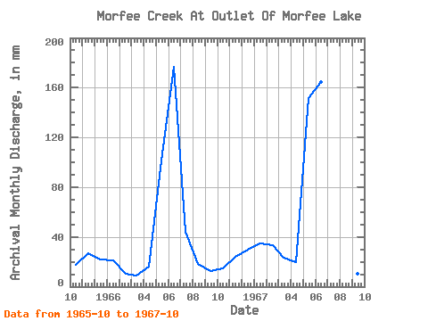
| Year | Jan | Feb | Mar | Apr | May | Jun | Jul | Aug | Sep | Oct | Nov | Dec | Annual | 1965 | 18.51 | 26.82 | 22.31 | 1966 | 21.96 | 9.53 | 9.31 | 16.14 | 104.98 | 176.96 | 45.53 | 18.97 | 12.35 | 15.29 | 24.37 | 30.70 | 485.80 | 1967 | 35.65 | 31.64 | 23.80 | 19.48 | 156.38 | 164.71 | 70.95 | 15.18 | 10.68 | 13.68 |
|---|
 Return to R-Arctic Net Home Page