|
|
|||||||||||||||||
| Point ID: 8687 | Downloads | Plots | Site Data | Code: 11604 |
|
|
|||||||||||||||||
| Download | |
|---|---|
| Site Descriptor Information | Site Time Series Data |
| Link to all available data | |
|
|
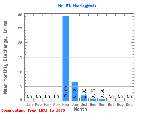
| View: | Statistics | Time Series |
| Units: | m3/s |
| Statistic | Jan | Feb | Mar | Apr | May | Jun | Jul | Aug | Sep | Oct | Nov | Dec | Annual |
|---|---|---|---|---|---|---|---|---|---|---|---|---|---|
| Mean | 29.00 | 6.43 | 1.92 | 0.77 | 0.58 | ||||||||
| Standard Deviation | 22.25 | 5.43 | 2.76 | 0.66 | 0.18 | ||||||||
| Min | 1.83 | 0.22 | 0.14 | 0.11 | 0.45 | ||||||||
| Max | 60.69 | 13.99 | 6.01 | 1.65 | 0.71 | ||||||||
| Coefficient of Variation | 0.77 | 0.84 | 1.44 | 0.85 | 0.31 |
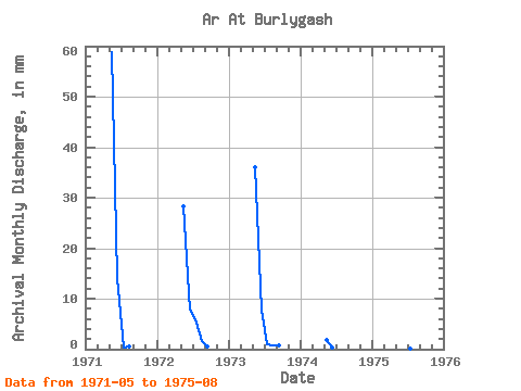
| Year | Jan | Feb | Mar | Apr | May | Jun | Jul | Aug | Sep | Oct | Nov | Dec | Annual | 1971 | 60.69 | 13.99 | 0.43 | 0.47 | 1972 | 29.22 | 7.88 | 6.01 | 1.65 | 0.45 | 1973 | 37.27 | 7.88 | 1.09 | 0.87 | 0.71 | 1974 | 1.83 | 0.22 | 1975 | 15.99 | 2.19 | 0.14 | 0.11 |
|---|
 Return to R-Arctic Net Home Page