|
|
|||||||||||||||||
| Point ID: 868 | Downloads | Plots | Site Data | Code: 07EE004 |
|
|
|||||||||||||||||
| Download | |
|---|---|
| Site Descriptor Information | Site Time Series Data |
| Link to all available data | |
|
|
| View: | Statistics | Time Series |
| Units: | m3/s |
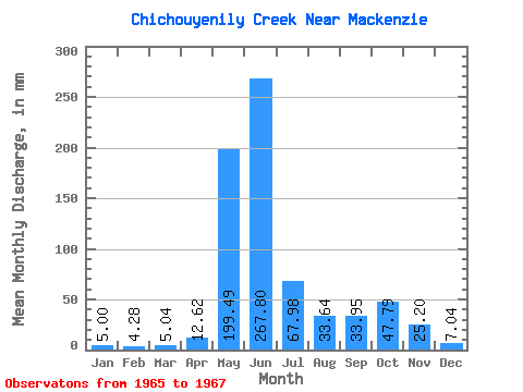
| Statistic | Jan | Feb | Mar | Apr | May | Jun | Jul | Aug | Sep | Oct | Nov | Dec | Annual |
|---|---|---|---|---|---|---|---|---|---|---|---|---|---|
| Mean | 5.02 | 4.32 | 5.06 | 12.64 | 199.46 | 267.80 | 67.97 | 33.63 | 33.95 | 47.78 | 25.20 | 7.04 | 717.38 |
| Standard Deviation | 0.92 | 1.05 | 1.23 | 2.00 | 20.69 | 94.30 | 37.98 | 31.53 | 35.64 | 6.76 | 4.16 | 0.47 | |
| Min | 4.37 | 3.58 | 4.19 | 11.22 | 184.83 | 201.12 | 41.12 | 11.33 | 8.75 | 40.00 | 22.26 | 6.70 | 717.38 |
| Max | 5.67 | 5.06 | 5.93 | 14.05 | 214.09 | 334.49 | 94.82 | 55.93 | 59.15 | 52.23 | 28.14 | 7.37 | 717.38 |
| Coefficient of Variation | 0.18 | 0.24 | 0.24 | 0.16 | 0.10 | 0.35 | 0.56 | 0.94 | 1.05 | 0.14 | 0.17 | 0.07 |
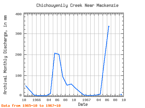
| Year | Jan | Feb | Mar | Apr | May | Jun | Jul | Aug | Sep | Oct | Nov | Dec | Annual | 1965 | 52.23 | 28.14 | 7.37 | 1966 | 4.37 | 3.58 | 4.19 | 14.05 | 214.09 | 201.12 | 94.82 | 55.93 | 59.15 | 40.00 | 22.26 | 6.70 | 717.38 | 1967 | 5.67 | 5.06 | 5.93 | 11.22 | 184.83 | 334.49 | 41.12 | 11.33 | 8.75 | 51.12 |
|---|
 Return to R-Arctic Net Home Page