|
|
|||||||||||||||||
| Point ID: 8677 | Downloads | Plots | Site Data | Code: 11593 |
|
|
|||||||||||||||||
| Download | |
|---|---|
| Site Descriptor Information | Site Time Series Data |
| Link to all available data | |

|

|
| View: | Statistics | Time Series |
| Units: | m3/s |
| Statistic | Jan | Feb | Mar | Apr | May | Jun | Jul | Aug | Sep | Oct | Nov | Dec | Annual |
|---|---|---|---|---|---|---|---|---|---|---|---|---|---|
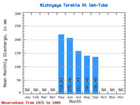
| Mean | 218.77 | 205.47 | 157.95 | 140.46 | 136.48 | ||||||||
| Standard Deviation | 284.71 | 278.73 | 210.93 | 163.36 | 129.67 | ||||||||
| Min | 32.79 | 22.22 | 13.12 | 9.84 | 36.50 | ||||||||
| Max | 967.36 | 946.87 | 688.63 | 497.89 | 404.67 | ||||||||
| Coefficient of Variation | 1.30 | 1.36 | 1.33 | 1.16 | 0.95 |
| Year | Jan | Feb | Mar | Apr | May | Jun | Jul | Aug | Sep | Oct | Nov | Dec | Annual | 1971 | 705.02 | 618.91 | 552.00 | 466.74 | 369.23 | 1972 | 309.88 | 368.17 | 291.85 | 237.74 | 206.30 | 1973 | 967.36 | 946.87 | 688.63 | 497.89 | 404.67 | 1974 | 231.73 | 151.29 | 104.93 | 103.84 | 113.73 | 1975 | 330.10 | 377.69 | 184.18 | 156.85 | 184.09 | 1976 | 61.21 | 22.22 | 13.12 | 9.84 | 39.67 | 1977 | 45.36 | 46.55 | 42.08 | 56.84 | 59.25 | 1978 | 58.48 | 56.60 | 58.48 | 58.48 | 53.96 | 1979 | 58.48 | 56.60 | 58.48 | 57.93 | 55.54 | 1980 | 58.48 | 56.60 | 58.48 | 58.48 | 55.54 | 1981 | 45.36 | 46.55 | 38.26 | 58.48 | 59.25 | 1982 | 32.79 | 42.32 | 37.71 | 22.41 | 1983 | 62.85 | 29.62 | 48.09 | 40.44 | 36.50 | 1985 | 95.64 | 56.60 | 34.98 |
|---|
 Return to R-Arctic Net Home Page