|
|
|||||||||||||||||
| Point ID: 867 | Downloads | Plots | Site Data | Code: 07EE003 |
|
|
|||||||||||||||||
| Download | |
|---|---|
| Site Descriptor Information | Site Time Series Data |
| Link to all available data | |
|
|
| View: | Statistics | Time Series |
| Units: | m3/s |
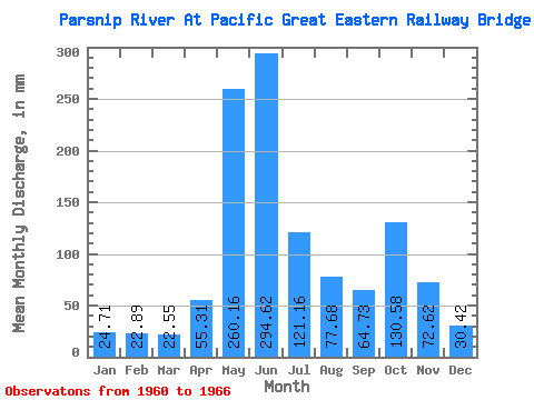
| Statistic | Jan | Feb | Mar | Apr | May | Jun | Jul | Aug | Sep | Oct | Nov | Dec | Annual |
|---|---|---|---|---|---|---|---|---|---|---|---|---|---|
| Mean | 24.71 | 23.09 | 22.55 | 55.31 | 260.12 | 294.62 | 121.14 | 77.67 | 64.73 | 130.56 | 72.62 | 30.42 | 1058.23 |
| Standard Deviation | 5.20 | 3.92 | 2.96 | 18.85 | 44.17 | 113.07 | 54.14 | 59.02 | 31.18 | 15.79 | 32.49 | 1.18 | |
| Min | 21.04 | 20.32 | 19.97 | 38.85 | 192.34 | 223.65 | 67.45 | 24.84 | 20.17 | 116.20 | 38.85 | 29.59 | 1058.23 |
| Max | 28.38 | 25.86 | 25.78 | 76.92 | 323.23 | 495.13 | 210.37 | 157.61 | 93.08 | 152.26 | 111.82 | 31.25 | 1058.23 |
| Coefficient of Variation | 0.21 | 0.17 | 0.13 | 0.34 | 0.17 | 0.38 | 0.45 | 0.76 | 0.48 | 0.12 | 0.45 | 0.04 |
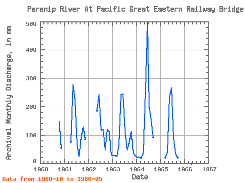
| Year | Jan | Feb | Mar | Apr | May | Jun | Jul | Aug | Sep | Oct | Nov | Dec | Annual | 1960 | 152.26 | 54.49 | 1961 | 76.92 | 287.83 | 223.65 | 67.45 | 24.84 | 93.08 | 131.56 | 85.32 | 1962 | 192.34 | 243.69 | 120.88 | 122.88 | 46.86 | 122.21 | 111.82 | 31.25 | 1963 | 28.38 | 25.86 | 25.78 | 65.28 | 251.10 | 244.98 | 114.87 | 48.42 | 71.75 | 116.20 | 38.85 | 29.59 | 1058.23 | 1964 | 21.04 | 20.32 | 19.97 | 38.85 | 263.79 | 495.13 | 210.37 | 157.61 | 91.79 | 1965 | 21.91 | 40.20 | 242.42 | 265.66 | 92.16 | 34.59 | 20.17 | 1966 | 323.23 |
|---|
 Return to R-Arctic Net Home Page