|
|
|||||||||||||||||
| Point ID: 8647 | Downloads | Plots | Site Data | Code: 11400 |
|
|
|||||||||||||||||
| Download | |
|---|---|
| Site Descriptor Information | Site Time Series Data |
| Link to all available data | |
|
|
| View: | Statistics | Time Series |
| Units: | m3/s |
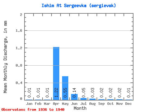
| Statistic | Jan | Feb | Mar | Apr | May | Jun | Jul | Aug | Sep | Oct | Nov | Dec | Annual |
|---|---|---|---|---|---|---|---|---|---|---|---|---|---|
| Mean | 0.01 | 0.01 | 0.01 | 1.22 | 0.55 | 0.14 | 0.05 | 0.03 | 0.02 | 0.02 | 0.02 | 0.01 | 1.28 |
| Standard Deviation | 0.01 | 0.01 | 0.01 | 1.69 | 0.35 | 0.11 | 0.02 | 0.02 | 0.01 | 0.01 | 0.00 | 0.00 | 0.41 |
| Min | 0.00 | 0.00 | 0.00 | 0.13 | 0.27 | 0.05 | 0.03 | 0.02 | 0.01 | 0.02 | 0.01 | 0.01 | 0.86 |
| Max | 0.02 | 0.03 | 0.02 | 4.18 | 1.04 | 0.30 | 0.08 | 0.05 | 0.03 | 0.03 | 0.02 | 0.01 | 1.68 |
| Coefficient of Variation | 1.16 | 1.56 | 1.00 | 1.38 | 0.63 | 0.79 | 0.28 | 0.47 | 0.33 | 0.23 | 0.17 | 0.14 | 0.32 |
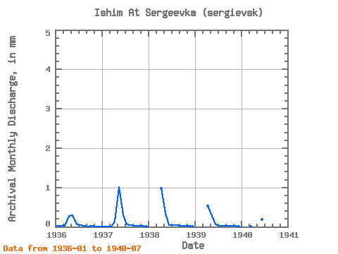
| Year | Jan | Feb | Mar | Apr | May | Jun | Jul | Aug | Sep | Oct | Nov | Dec | Annual | 1936 | 0.02 | 0.03 | 0.02 | 0.28 | 0.30 | 0.07 | 0.06 | 0.02 | 0.01 | 0.02 | 0.01 | 0.01 | 0.86 | 1937 | 0.01 | 0.01 | 0.01 | 0.13 | 1.04 | 0.30 | 0.08 | 0.04 | 0.03 | 0.02 | 0.02 | 0.01 | 1.68 | 1938 | 0.00 | 0.00 | 0.00 | 0.96 | 0.34 | 0.05 | 0.05 | 0.05 | 0.03 | 0.03 | 0.02 | 0.01 | 1.56 | 1939 | 0.00 | 0.00 | 0.00 | 0.53 | 0.27 | 0.07 | 0.03 | 0.03 | 0.02 | 0.02 | 0.02 | 0.01 | 1.01 | 1940 | 0.00 | 0.00 | 0.01 | 4.18 | 0.79 | 0.19 | 0.06 |
|---|
 Return to R-Arctic Net Home Page