|
|
|||||||||||||||||
| Point ID: 8628 | Downloads | Plots | Site Data | Code: 11294 |
|
|
|||||||||||||||||
| Download | |
|---|---|
| Site Descriptor Information | Site Time Series Data |
| Link to all available data | |
|
|
| View: | Statistics | Time Series |
| Units: | m3/s |
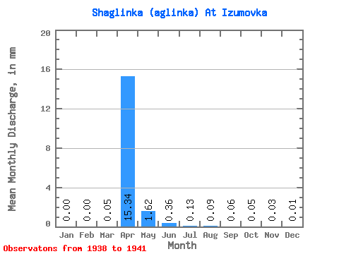
| Statistic | Jan | Feb | Mar | Apr | May | Jun | Jul | Aug | Sep | Oct | Nov | Dec | Annual |
|---|---|---|---|---|---|---|---|---|---|---|---|---|---|
| Mean | 0.00 | 0.00 | 0.03 | 9.37 | 0.99 | 0.22 | 0.08 | 0.05 | 0.03 | 0.03 | 0.02 | 0.00 | 10.94 |
| Standard Deviation | 0.00 | 0.00 | 0.06 | 18.15 | 1.49 | 0.09 | 0.03 | 0.03 | 0.02 | 0.02 | 0.01 | 0.01 | 19.99 |
| Min | 0.00 | 0.00 | 0.00 | 0.01 | 0.09 | 0.12 | 0.05 | 0.02 | 0.01 | 0.01 | 0.01 | 0.00 | 0.57 |
| Max | 0.00 | 0.00 | 0.12 | 36.59 | 3.21 | 0.33 | 0.11 | 0.10 | 0.05 | 0.05 | 0.03 | 0.01 | 40.91 |
| Coefficient of Variation | 2.00 | 1.94 | 1.51 | 0.40 | 0.38 | 0.60 | 0.53 | 0.57 | 0.81 | 2.00 | 1.83 |
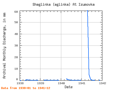
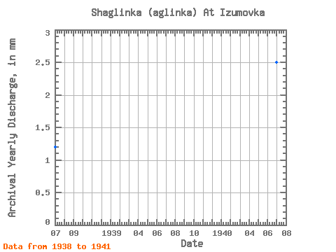
| Year | Jan | Feb | Mar | Apr | May | Jun | Jul | Aug | Sep | Oct | Nov | Dec | Annual | 1938 | 0.00 | 0.00 | 0.00 | 0.01 | 0.29 | 0.23 | 0.10 | 0.04 | 0.03 | 0.02 | 0.02 | 0.00 | 0.74 | 1939 | 0.00 | 0.00 | 0.12 | 0.14 | 0.09 | 0.12 | 0.05 | 0.02 | 0.01 | 0.01 | 0.01 | 0.00 | 0.57 | 1940 | 0.00 | 0.00 | 0.00 | 0.72 | 0.36 | 0.18 | 0.06 | 0.05 | 0.05 | 0.05 | 0.03 | 0.01 | 1.53 | 1941 | 0.00 | 0.00 | 0.00 | 36.59 | 3.21 | 0.33 | 0.11 | 0.10 | 0.05 | 0.04 | 0.01 | 0.00 | 40.91 |
|---|
 Return to R-Arctic Net Home Page