|
|
|||||||||||||||||
| Point ID: 853 | Downloads | Plots | Site Data | Code: 07EA001 |
|
|
|||||||||||||||||
| Download | |
|---|---|
| Site Descriptor Information | Site Time Series Data |
| Link to all available data | |
|
|
| View: | Statistics | Time Series |
| Units: | m3/s |
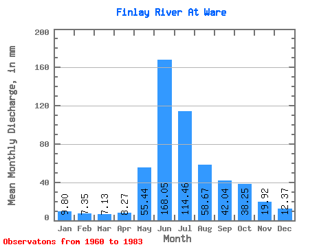
| Statistic | Jan | Feb | Mar | Apr | May | Jun | Jul | Aug | Sep | Oct | Nov | Dec | Annual |
|---|---|---|---|---|---|---|---|---|---|---|---|---|---|
| Mean | 9.80 | 7.42 | 7.12 | 8.27 | 55.43 | 168.05 | 114.44 | 58.66 | 42.04 | 38.24 | 19.92 | 12.37 | 540.15 |
| Standard Deviation | 1.56 | 1.10 | 1.03 | 1.52 | 24.23 | 32.27 | 29.71 | 13.93 | 8.77 | 13.13 | 4.82 | 2.81 | 60.05 |
| Min | 5.86 | 4.99 | 5.45 | 6.09 | 23.35 | 113.02 | 58.87 | 34.74 | 30.59 | 22.17 | 12.80 | 8.78 | 409.69 |
| Max | 13.12 | 9.34 | 9.55 | 11.35 | 118.46 | 259.20 | 166.95 | 92.40 | 60.01 | 76.48 | 31.52 | 21.16 | 629.92 |
| Coefficient of Variation | 0.16 | 0.15 | 0.14 | 0.18 | 0.44 | 0.19 | 0.26 | 0.24 | 0.21 | 0.34 | 0.24 | 0.23 | 0.11 |
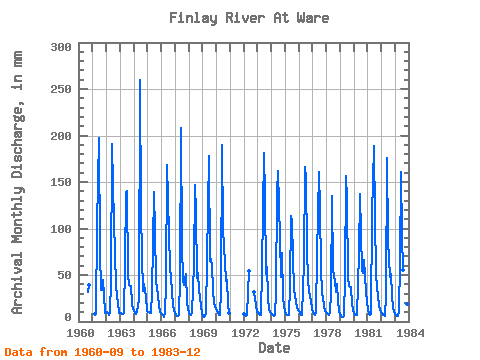
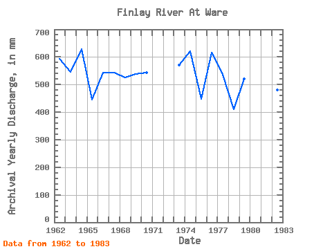
| Year | Jan | Feb | Mar | Apr | May | Jun | Jul | Aug | Sep | Oct | Nov | Dec | Annual | 1960 | 31.52 | 40.05 | 1961 | 8.71 | 9.13 | 106.16 | 197.55 | 78.17 | 34.74 | 34.33 | 45.84 | 28.49 | 9.36 | 1962 | 10.59 | 9.10 | 7.72 | 9.62 | 44.63 | 191.25 | 151.03 | 73.58 | 39.93 | 27.02 | 20.83 | 9.24 | 593.29 | 1963 | 9.14 | 8.33 | 8.28 | 9.29 | 64.17 | 139.64 | 145.24 | 51.63 | 39.46 | 39.33 | 19.05 | 14.31 | 545.62 | 1964 | 11.31 | 8.53 | 8.18 | 11.35 | 23.35 | 259.20 | 122.56 | 72.86 | 32.69 | 41.26 | 26.15 | 12.21 | 629.92 | 1965 | 11.00 | 9.34 | 9.55 | 9.39 | 31.12 | 139.41 | 100.85 | 45.84 | 35.03 | 28.95 | 16.70 | 10.25 | 446.84 | 1966 | 8.61 | 6.29 | 5.53 | 9.64 | 41.50 | 167.90 | 135.59 | 59.11 | 48.34 | 33.29 | 17.47 | 11.53 | 543.56 | 1967 | 9.46 | 7.01 | 6.54 | 6.94 | 47.05 | 207.59 | 84.44 | 46.32 | 39.70 | 52.59 | 21.27 | 13.85 | 542.68 | 1968 | 9.29 | 7.56 | 7.55 | 9.08 | 63.45 | 146.41 | 121.84 | 47.77 | 52.31 | 34.98 | 17.86 | 8.78 | 525.53 | 1969 | 5.86 | 4.99 | 5.91 | 7.66 | 68.76 | 177.94 | 67.55 | 69.72 | 60.01 | 34.74 | 19.50 | 15.61 | 537.73 | 1970 | 11.61 | 8.11 | 6.73 | 6.72 | 34.26 | 190.08 | 103.02 | 65.38 | 43.43 | 46.32 | 18.40 | 9.51 | 543.04 | 1972 | 8.71 | 6.24 | 6.25 | 7.43 | 56.21 | 33.05 | 17.89 | 11.03 | 1973 | 10.33 | 7.96 | 7.48 | 7.08 | 58.14 | 181.44 | 137.76 | 53.08 | 58.61 | 27.50 | 12.80 | 10.98 | 572.11 | 1974 | 8.23 | 6.55 | 5.94 | 6.70 | 32.33 | 138.01 | 166.95 | 92.40 | 47.64 | 76.48 | 27.79 | 16.09 | 621.70 | 1975 | 11.15 | 7.69 | 7.74 | 6.87 | 39.33 | 113.02 | 111.22 | 69.97 | 34.79 | 22.17 | 14.03 | 13.17 | 449.30 | 1976 | 11.53 | 8.53 | 7.31 | 7.08 | 65.14 | 166.03 | 159.23 | 80.58 | 44.13 | 34.02 | 21.58 | 14.02 | 616.68 | 1977 | 10.59 | 7.72 | 6.90 | 10.25 | 73.83 | 160.42 | 123.53 | 59.83 | 30.59 | 25.82 | 16.21 | 11.24 | 535.12 | 1978 | 9.14 | 7.65 | 6.78 | 9.60 | 32.09 | 135.20 | 58.87 | 43.67 | 31.99 | 41.50 | 22.04 | 11.29 | 409.69 | 1979 | 8.83 | 5.96 | 5.45 | 6.09 | 48.01 | 156.45 | 134.62 | 48.25 | 38.53 | 38.12 | 18.35 | 13.22 | 520.27 | 1980 | 9.26 | 6.88 | 7.26 | 7.15 | 76.00 | 137.07 | 98.19 | 57.66 | 52.07 | 68.28 | 31.52 | 21.16 | 570.33 | 1981 | 13.12 | 7.87 | 7.50 | 8.17 | 118.46 | 188.44 | 115.81 | 52.84 | 37.60 | 27.26 | 17.44 | 12.76 | 605.35 | 1982 | 9.24 | 6.46 | 6.90 | 6.35 | 29.92 | 175.37 | 90.47 | 49.70 | 51.61 | 29.19 | 14.27 | 10.78 | 480.34 | 1983 | 8.85 | 6.95 | 6.54 | 10.28 | 65.62 | 160.66 | 96.26 | 56.94 | 40.63 | 31.85 | 18.66 | 11.75 | 513.92 |
|---|
 Return to R-Arctic Net Home Page