|
|
|||||||||||||||||
| Point ID: 8523 | Downloads | Plots | Site Data | Code: 10557 |
|
|
|||||||||||||||||
| Download | |
|---|---|
| Site Descriptor Information | Site Time Series Data |
| Link to all available data | |
|
|
| View: | Statistics | Time Series |
| Units: | m3/s |
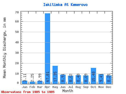
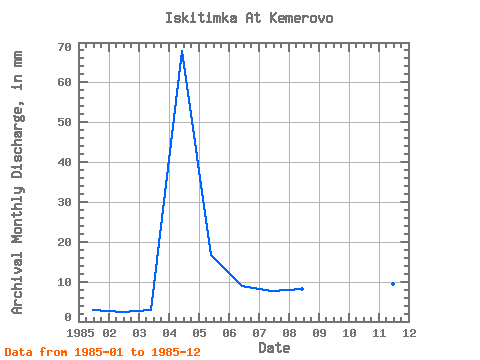
| Statistic | Jan | Feb | Mar | Apr | May | Jun | Jul | Aug | Sep | Oct | Nov | Dec | Annual |
|---|---|---|---|---|---|---|---|---|---|---|---|---|---|
| Mean | 3.11 | 2.27 | 2.99 | 67.81 | 17.34 | 8.91 | 8.02 | 8.47 | 8.09 | 15.48 | 9.41 | 8.25 | 160.57 |
| Standard Deviation | |||||||||||||
| Min | 3.11 | 2.27 | 2.99 | 67.81 | 17.34 | 8.91 | 8.02 | 8.47 | 8.09 | 15.48 | 9.41 | 8.25 | 160.57 |
| Max | 3.11 | 2.27 | 2.99 | 67.81 | 17.34 | 8.91 | 8.02 | 8.47 | 8.09 | 15.48 | 9.41 | 8.25 | 160.57 |
| Coefficient of Variation |
| Year | Jan | Feb | Mar | Apr | May | Jun | Jul | Aug | Sep | Oct | Nov | Dec | Annual | 1985 | 3.11 | 2.27 | 2.99 | 67.81 | 17.34 | 8.91 | 8.02 | 8.47 | 8.09 | 15.48 | 9.41 | 8.25 | 160.57 |
|---|
 Return to R-Arctic Net Home Page