|
|
|||||||||||||||||
| Point ID: 8481 | Downloads | Plots | Site Data | Code: 10321 |
|
|
|||||||||||||||||
| Download | |
|---|---|
| Site Descriptor Information | Site Time Series Data |
| Link to all available data | |
|
|
| View: | Statistics | Time Series |
| Units: | m3/s |
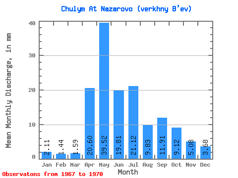
| Statistic | Jan | Feb | Mar | Apr | May | Jun | Jul | Aug | Sep | Oct | Nov | Dec | Annual |
|---|---|---|---|---|---|---|---|---|---|---|---|---|---|
| Mean | 2.11 | 1.45 | 1.59 | 20.60 | 39.52 | 19.81 | 21.12 | 9.83 | 11.91 | 9.12 | 5.08 | 3.68 | 138.81 |
| Standard Deviation | 0.75 | 0.52 | 0.42 | 7.23 | |||||||||
| Min | 1.58 | 1.08 | 1.29 | 15.49 | 39.52 | 19.81 | 21.12 | 9.83 | 11.91 | 9.12 | 5.08 | 3.68 | 138.81 |
| Max | 2.63 | 1.81 | 1.88 | 25.71 | 39.52 | 19.81 | 21.12 | 9.83 | 11.91 | 9.12 | 5.08 | 3.68 | 138.81 |
| Coefficient of Variation | 0.35 | 0.36 | 0.26 | 0.35 |
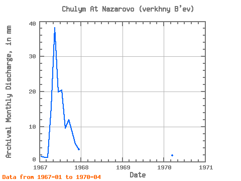
| Year | Jan | Feb | Mar | Apr | May | Jun | Jul | Aug | Sep | Oct | Nov | Dec | Annual | 1967 | 1.58 | 1.08 | 1.29 | 15.49 | 39.52 | 19.81 | 21.12 | 9.83 | 11.91 | 9.12 | 5.08 | 3.68 | 138.81 | 1970 | 2.63 | 1.81 | 1.88 | 25.71 |
|---|
 Return to R-Arctic Net Home Page