|
|
|||||||||||||||||
| Point ID: 8471 | Downloads | Plots | Site Data | Code: 10291 |
|
|
|||||||||||||||||
| Download | |
|---|---|
| Site Descriptor Information | Site Time Series Data |
| Link to all available data | |
|
|
| View: | Statistics | Time Series |
| Units: | m3/s |
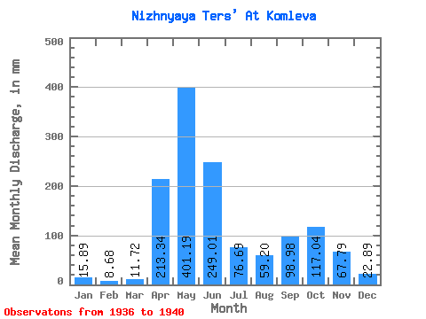
| Statistic | Jan | Feb | Mar | Apr | May | Jun | Jul | Aug | Sep | Oct | Nov | Dec | Annual |
|---|---|---|---|---|---|---|---|---|---|---|---|---|---|
| Mean | 15.88 | 8.76 | 11.72 | 213.34 | 401.13 | 249.01 | 76.68 | 59.19 | 98.98 | 117.02 | 67.79 | 22.89 | 1008.30 |
| Standard Deviation | 66.48 | 158.32 | 39.24 | 41.17 | 40.81 | 63.59 | |||||||
| Min | 15.88 | 8.76 | 11.72 | 213.34 | 343.33 | 93.05 | 26.32 | 27.47 | 41.43 | 53.10 | 67.79 | 22.89 | 1008.30 |
| Max | 15.88 | 8.76 | 11.72 | 213.34 | 494.40 | 456.37 | 121.31 | 128.41 | 149.54 | 204.63 | 67.79 | 22.89 | 1008.30 |
| Coefficient of Variation | 0.17 | 0.64 | 0.51 | 0.70 | 0.41 | 0.54 |
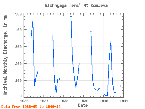
| Year | Jan | Feb | Mar | Apr | May | Jun | Jul | Aug | Sep | Oct | Nov | Dec | Annual | 1936 | 366.22 | 456.37 | 73.70 | 128.41 | 149.54 | 1937 | 363.32 | 109.18 | 27.47 | 109.22 | 111.93 | 1938 | 494.40 | 221.54 | 121.31 | 62.49 | 115.86 | 204.63 | 1939 | 400.56 | 110.77 | 52.87 | 47.15 | 41.43 | 53.10 | 1940 | 15.88 | 8.76 | 11.72 | 213.34 | 343.33 | 93.05 | 26.32 | 30.44 | 78.87 | 98.42 | 67.79 | 22.89 | 1008.30 |
|---|
 Return to R-Arctic Net Home Page