|
|
|||||||||||||||||
| Point ID: 8465 | Downloads | Plots | Site Data | Code: 10256 |
|
|
|||||||||||||||||
| Download | |
|---|---|
| Site Descriptor Information | Site Time Series Data |
| Link to all available data | |
|
|
| View: | Statistics | Time Series |
| Units: | m3/s |
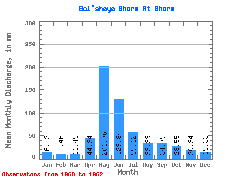
| Statistic | Jan | Feb | Mar | Apr | May | Jun | Jul | Aug | Sep | Oct | Nov | Dec | Annual |
|---|---|---|---|---|---|---|---|---|---|---|---|---|---|
| Mean | 16.12 | 11.56 | 11.45 | 44.34 | 201.73 | 129.34 | 59.11 | 33.39 | 34.79 | 28.54 | 20.35 | 15.33 | 611.30 |
| Standard Deviation | 0.87 | 1.14 | 1.50 | 17.12 | 48.59 | 11.46 | 10.34 | 11.59 | 18.95 | 14.19 | 6.04 | 5.02 | 56.52 |
| Min | 15.50 | 10.76 | 10.39 | 32.23 | 167.38 | 121.24 | 51.80 | 25.19 | 16.37 | 20.26 | 15.52 | 10.92 | 571.33 |
| Max | 16.74 | 12.36 | 12.51 | 56.44 | 236.09 | 137.44 | 66.42 | 41.58 | 54.23 | 44.93 | 27.11 | 20.79 | 651.27 |
| Coefficient of Variation | 0.05 | 0.10 | 0.13 | 0.39 | 0.24 | 0.09 | 0.17 | 0.35 | 0.55 | 0.50 | 0.30 | 0.33 | 0.09 |
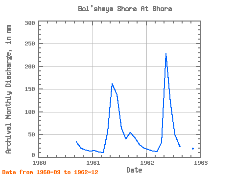
| Year | Jan | Feb | Mar | Apr | May | Jun | Jul | Aug | Sep | Oct | Nov | Dec | Annual | 1960 | 33.76 | 20.26 | 15.52 | 14.27 | 1961 | 15.50 | 10.76 | 10.39 | 56.44 | 167.38 | 137.44 | 66.42 | 41.58 | 54.23 | 44.93 | 27.11 | 20.79 | 651.27 | 1962 | 16.74 | 12.36 | 12.51 | 32.23 | 236.09 | 121.24 | 51.80 | 25.19 | 16.37 | 20.44 | 18.42 | 10.92 | 571.33 |
|---|
 Return to R-Arctic Net Home Page