|
|
|||||||||||||||||
| Point ID: 8424 | Downloads | Plots | Site Data | Code: 10094 |
|
|
|||||||||||||||||
| Download | |
|---|---|
| Site Descriptor Information | Site Time Series Data |
| Link to all available data | |
|
|
| View: | Statistics | Time Series |
| Units: | m3/s |
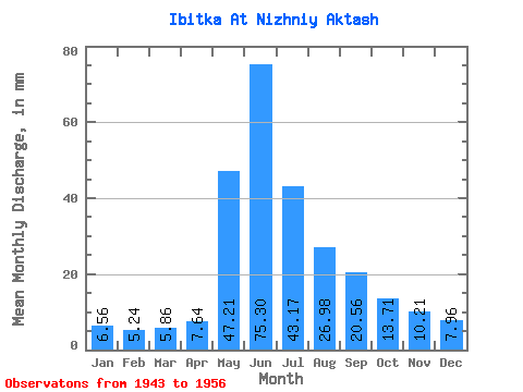
| Statistic | Jan | Feb | Mar | Apr | May | Jun | Jul | Aug | Sep | Oct | Nov | Dec | Annual |
|---|---|---|---|---|---|---|---|---|---|---|---|---|---|
| Mean | 6.55 | 5.28 | 5.85 | 7.64 | 47.22 | 75.29 | 43.17 | 26.98 | 20.55 | 13.71 | 10.21 | 7.95 | 273.31 |
| Standard Deviation | 1.99 | 1.43 | 1.15 | 3.86 | 37.42 | 52.78 | 23.68 | 4.82 | 6.67 | 5.57 | 3.29 | 2.12 | 79.10 |
| Min | 4.40 | 4.01 | 4.20 | 4.26 | 15.19 | 38.30 | 24.38 | 20.39 | 10.64 | 7.00 | 5.61 | 5.00 | 169.77 |
| Max | 9.21 | 7.28 | 6.81 | 12.96 | 94.13 | 151.46 | 74.74 | 30.58 | 25.15 | 21.58 | 14.12 | 10.39 | 345.63 |
| Coefficient of Variation | 0.30 | 0.27 | 0.20 | 0.51 | 0.79 | 0.70 | 0.55 | 0.18 | 0.33 | 0.41 | 0.32 | 0.27 | 0.29 |
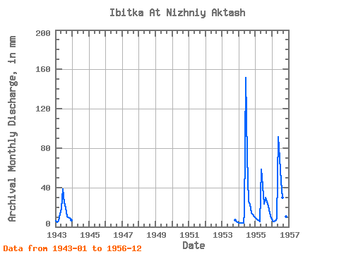
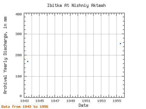
| Year | Jan | Feb | Mar | Apr | May | Jun | Jul | Aug | Sep | Oct | Nov | Dec | Annual | 1943 | 6.20 | 4.55 | 6.39 | 12.96 | 18.99 | 38.30 | 25.58 | 20.39 | 10.64 | 9.99 | 8.70 | 7.39 | 169.77 | 1953 | 7.00 | 5.61 | 5.00 | 1954 | 4.40 | 4.01 | 4.20 | 4.26 | 15.19 | 151.46 | 74.74 | 26.38 | 23.02 | 14.79 | 12.38 | 10.39 | 345.63 | 1955 | 9.21 | 7.28 | 6.81 | 5.42 | 60.55 | 41.20 | 24.38 | 30.58 | 25.15 | 21.58 | 14.12 | 9.59 | 254.78 | 1956 | 6.39 | 5.28 | 6.00 | 7.93 | 94.13 | 70.22 | 47.96 | 30.58 | 23.41 | 15.19 | 10.25 | 7.39 | 323.06 |
|---|
 Return to R-Arctic Net Home Page