|
|
|||||||||||||||||
| Point ID: 8390 | Downloads | Plots | Site Data | Code: 9480 |
|
|
|||||||||||||||||
| Download | |
|---|---|
| Site Descriptor Information | Site Time Series Data |
| Link to all available data | |
|
|
| View: | Statistics | Time Series |
| Units: | m3/s |
| Statistic | Jan | Feb | Mar | Apr | May | Jun | Jul | Aug | Sep | Oct | Nov | Dec | Annual |
|---|---|---|---|---|---|---|---|---|---|---|---|---|---|
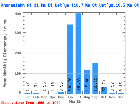
| Mean | 1.72 | 1.72 | 1.36 | 1.19 | 9.56 | 340.20 | 395.64 | 115.39 | 153.15 | 32.70 | 3.33 | 3.16 | 1055.70 |
| Standard Deviation | 1.22 | 1.37 | 1.05 | 0.93 | 7.57 | 239.15 | 270.67 | 101.44 | 51.84 | 45.71 | 1.86 | 2.96 | 176.03 |
| Min | 0.00 | 0.00 | 0.00 | 0.00 | 2.23 | 123.03 | 167.86 | 25.42 | 93.26 | 5.43 | 1.50 | 0.94 | 815.92 |
| Max | 2.81 | 2.92 | 2.33 | 1.97 | 16.88 | 617.01 | 720.92 | 246.45 | 216.94 | 100.91 | 6.10 | 8.34 | 1205.51 |
| Coefficient of Variation | 0.71 | 0.80 | 0.78 | 0.78 | 0.79 | 0.70 | 0.68 | 0.88 | 0.34 | 1.40 | 0.56 | 0.94 | 0.17 |
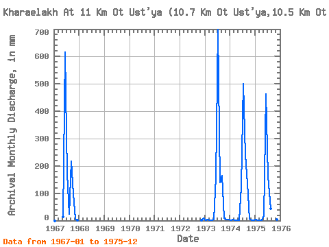
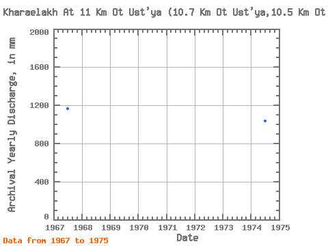
| Year | Jan | Feb | Mar | Apr | May | Jun | Jul | Aug | Sep | Oct | Nov | Dec | Annual | 1966 | 1967 | 0.00 | 0.00 | 0.00 | 0.00 | 15.23 | 617.01 | 177.56 | 25.42 | 216.94 | 100.91 | 6.10 | 1.94 | 1167.68 | 1972 | 1.50 | 8.34 | 1973 | 1.84 | 2.74 | 2.33 | 1.97 | 3.88 | 158.71 | 720.92 | 143.60 | 165.29 | 8.15 | 4.23 | 2.62 | 1205.51 | 1974 | 2.23 | 2.92 | 2.04 | 1.88 | 2.23 | 123.03 | 516.19 | 246.45 | 137.11 | 5.43 | 2.07 | 1.94 | 1033.70 | 1975 | 2.81 | 1.24 | 1.07 | 0.92 | 16.88 | 462.05 | 167.86 | 46.09 | 93.26 | 16.30 | 2.72 | 0.94 | 815.92 |
|---|
 Return to R-Arctic Net Home Page