|
|
|||||||||||||||||
| Point ID: 8375 | Downloads | Plots | Site Data | Code: 9441 |
|
|
|||||||||||||||||
| Download | |
|---|---|
| Site Descriptor Information | Site Time Series Data |
| Link to all available data | |
|
|
| View: | Statistics | Time Series |
| Units: | m3/s |
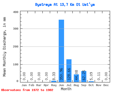
| Statistic | Jan | Feb | Mar | Apr | May | Jun | Jul | Aug | Sep | Oct | Nov | Dec | Annual |
|---|---|---|---|---|---|---|---|---|---|---|---|---|---|
| Mean | 0.00 | 0.00 | 0.00 | 0.00 | 8.33 | 350.96 | 128.64 | 44.07 | 62.25 | 5.10 | 0.13 | 0.00 | 602.20 |
| Standard Deviation | 0.00 | 0.00 | 0.00 | 0.00 | 26.34 | 89.06 | 95.38 | 26.77 | 24.88 | 2.50 | 0.26 | 0.00 | 84.99 |
| Min | 0.00 | 0.00 | 0.00 | 0.00 | 0.00 | 177.47 | 10.99 | 9.25 | 22.95 | 1.68 | 0.00 | 0.00 | 463.91 |
| Max | 0.00 | 0.00 | 0.00 | 0.00 | 83.29 | 470.25 | 300.19 | 96.02 | 104.13 | 8.10 | 0.84 | 0.00 | 711.18 |
| Coefficient of Variation | 3.16 | 0.25 | 0.74 | 0.61 | 0.40 | 0.49 | 2.03 | 0.14 |
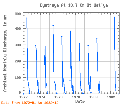
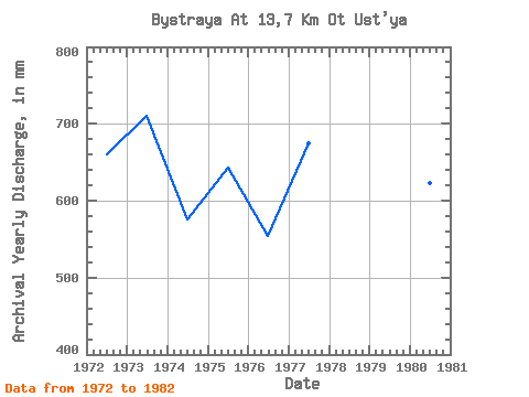
| Year | Jan | Feb | Mar | Apr | May | Jun | Jul | Aug | Sep | Oct | Nov | Dec | Annual | 1972 | 0.00 | 0.00 | 0.00 | 0.00 | 0.00 | 465.78 | 91.97 | 67.09 | 30.23 | 1.68 | 0.00 | 0.00 | 661.13 | 1973 | 0.00 | 0.00 | 0.00 | 0.00 | 0.00 | 296.71 | 274.74 | 42.80 | 92.93 | 3.93 | 0.11 | 0.00 | 711.18 | 1974 | 0.00 | 0.00 | 0.00 | 0.00 | 0.00 | 177.47 | 300.19 | 37.02 | 61.58 | 3.24 | 0.00 | 0.00 | 576.90 | 1975 | 0.00 | 0.00 | 0.00 | 0.00 | 0.00 | 419.87 | 79.24 | 71.72 | 58.78 | 8.10 | 0.84 | 0.00 | 642.73 | 1976 | 0.00 | 0.00 | 0.00 | 0.00 | 0.00 | 351.57 | 45.69 | 96.02 | 51.50 | 5.55 | 0.22 | 0.00 | 553.83 | 1977 | 0.00 | 0.00 | 0.00 | 0.00 | 83.29 | 385.72 | 127.83 | 9.25 | 63.26 | 3.93 | 0.00 | 0.00 | 675.85 | 1978 | 0.00 | 0.00 | 0.00 | 0.00 | 0.00 | 307.35 | 97.17 | 31.81 | 22.95 | 2.02 | 0.11 | 0.00 | 463.91 | 1979 | 0.00 | 0.00 | 0.00 | 0.00 | 0.00 | 297.27 | 10.99 | 42.22 | 104.13 | 8.10 | 0.00 | 0.00 | 467.49 | 1980 | 0.00 | 0.00 | 0.00 | 0.00 | 0.00 | 337.58 | 182.20 | 19.09 | 75.58 | 6.36 | 0.00 | 0.00 | 623.13 | 1982 | 0.00 | 0.00 | 0.00 | 0.00 | 0.00 | 470.25 | 76.35 | 23.71 | 61.58 | 8.10 | 0.00 | 0.00 | 645.86 |
|---|
 Return to R-Arctic Net Home Page