|
|
|||||||||||||||||
| Point ID: 8303 | Downloads | Plots | Site Data | Code: 9178 |
|
|
|||||||||||||||||
| Download | |
|---|---|
| Site Descriptor Information | Site Time Series Data |
| Link to all available data | |
|
|
| View: | Statistics | Time Series |
| Units: | m3/s |
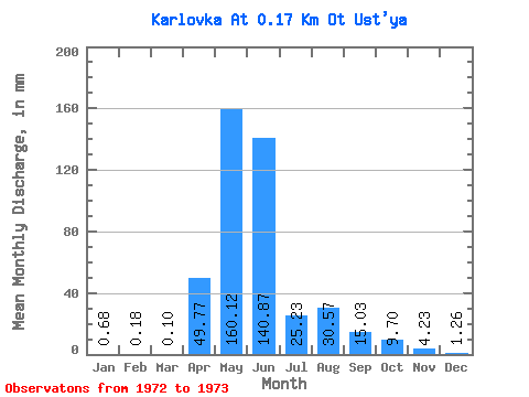
| Statistic | Jan | Feb | Mar | Apr | May | Jun | Jul | Aug | Sep | Oct | Nov | Dec | Annual |
|---|---|---|---|---|---|---|---|---|---|---|---|---|---|
| Mean | 0.68 | 0.18 | 0.10 | 49.77 | 160.10 | 140.87 | 25.23 | 30.56 | 15.03 | 9.70 | 4.23 | 1.31 | 426.61 |
| Standard Deviation | 2.06 | 5.31 | 6.86 | 3.32 | 0.89 | ||||||||
| Min | 0.68 | 0.18 | 0.10 | 49.77 | 160.10 | 140.87 | 25.23 | 29.11 | 11.27 | 4.85 | 1.88 | 0.68 | 426.61 |
| Max | 0.68 | 0.18 | 0.10 | 49.77 | 160.10 | 140.87 | 25.23 | 32.02 | 18.78 | 14.55 | 6.57 | 1.94 | 426.61 |
| Coefficient of Variation | 0.07 | 0.35 | 0.71 | 0.79 | 0.68 |
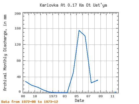
| Year | Jan | Feb | Mar | Apr | May | Jun | Jul | Aug | Sep | Oct | Nov | Dec | Annual | 1972 | 29.11 | 18.78 | 14.55 | 6.57 | 1.94 | 1973 | 0.68 | 0.18 | 0.10 | 49.77 | 160.10 | 140.87 | 25.23 | 32.02 | 11.27 | 4.85 | 1.88 | 0.68 | 426.61 |
|---|
 Return to R-Arctic Net Home Page