|
|
|||||||||||||||||
| Point ID: 8261 | Downloads | Plots | Site Data | Code: 8368 |
|
|
|||||||||||||||||
| Download | |
|---|---|
| Site Descriptor Information | Site Time Series Data |
| Link to all available data | |

|

|
| View: | Statistics | Time Series |
| Units: | m3/s |
| Statistic | Jan | Feb | Mar | Apr | May | Jun | Jul | Aug | Sep | Oct | Nov | Dec | Annual |
|---|---|---|---|---|---|---|---|---|---|---|---|---|---|
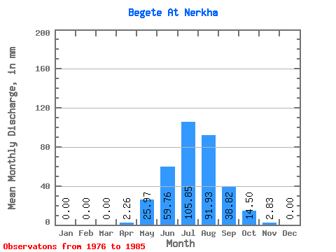
| Mean | 0.00 | 0.00 | 0.00 | 2.22 | 25.96 | 59.77 | 105.84 | 91.92 | 38.83 | 14.46 | 2.85 | 0.00 | 329.96 |
| Standard Deviation | 0.00 | 0.00 | 0.00 | 4.45 | 11.04 | 34.90 | 78.67 | 51.24 | 28.64 | 10.04 | 2.08 | 0.00 | 166.88 |
| Min | 0.00 | 0.00 | 0.00 | 0.11 | 11.69 | 19.24 | 10.53 | 29.24 | 13.58 | 5.26 | 0.57 | 0.00 | 127.71 |
| Max | 0.00 | 0.00 | 0.00 | 14.71 | 49.12 | 126.77 | 247.92 | 162.55 | 96.21 | 37.42 | 8.04 | 0.00 | 603.41 |
| Coefficient of Variation | 2.00 | 0.42 | 0.58 | 0.74 | 0.56 | 0.74 | 0.69 | 0.73 | 0.51 |
| Year | Jan | Feb | Mar | Apr | May | Jun | Jul | Aug | Sep | Oct | Nov | Dec | Annual | 1976 | 0.79 | 16.37 | 52.07 | 195.29 | 128.64 | 23.77 | 9.12 | 0.57 | 0.00 | 1977 | 0.00 | 0.00 | 0.00 | 0.91 | 32.74 | 53.20 | 64.32 | 54.96 | 15.85 | 8.65 | 1.92 | 0.00 | 230.73 | 1978 | 0.00 | 0.00 | 0.00 | 1.47 | 19.88 | 19.24 | 92.39 | 98.23 | 21.51 | 5.26 | 2.15 | 0.00 | 256.91 | 1979 | 0.00 | 0.00 | 0.00 | 0.57 | 22.22 | 31.69 | 10.53 | 29.24 | 24.90 | 7.60 | 1.36 | 0.00 | 127.71 | 1980 | 0.00 | 0.00 | 0.00 | 0.45 | 19.88 | 92.81 | 178.92 | 162.55 | 83.76 | 37.42 | 8.04 | 0.00 | 579.40 | 1981 | 0.00 | 0.00 | 0.00 | 14.71 | 29.24 | 89.49 | 45.73 | 156.77 | 46.48 | 16.44 | 3.96 | 0.00 | 400.59 | 1982 | 0.00 | 0.00 | 0.00 | 2.49 | 49.12 | 126.77 | 49.12 | 47.95 | 32.82 | 11.58 | 2.15 | 0.00 | 321.57 | 1983 | 0.00 | 0.00 | 0.00 | 0.11 | 11.69 | 33.96 | 44.44 | 52.62 | 29.43 | 15.20 | 3.28 | 0.00 | 189.50 | 1984 | 0.00 | 0.00 | 0.00 | 0.11 | 36.25 | 26.03 | 129.81 | 47.95 | 13.58 | 7.60 | 1.81 | 0.00 | 259.78 | 1985 | 0.00 | 0.00 | 0.00 | 0.57 | 22.22 | 72.44 | 247.92 | 140.33 | 96.21 | 25.73 | 3.28 | 0.00 | 603.41 |
|---|
 Return to R-Arctic Net Home Page