|
|
|||||||||||||||||
| Point ID: 8238 | Downloads | Plots | Site Data | Code: 8294 |
|
|
|||||||||||||||||
| Download | |
|---|---|
| Site Descriptor Information | Site Time Series Data |
| Link to all available data | |
|
|
| View: | Statistics | Time Series |
| Units: | m3/s |
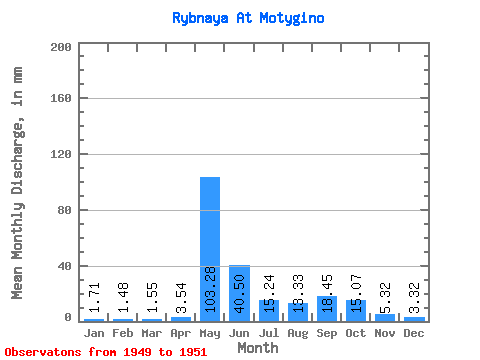
| Statistic | Jan | Feb | Mar | Apr | May | Jun | Jul | Aug | Sep | Oct | Nov | Dec | Annual |
|---|---|---|---|---|---|---|---|---|---|---|---|---|---|
| Mean | 1.71 | 1.50 | 1.55 | 3.54 | 103.27 | 40.50 | 15.24 | 13.33 | 18.45 | 15.06 | 5.32 | 3.32 | 242.78 |
| Standard Deviation | 0.09 | 0.08 | 0.16 | 3.08 | 49.57 | 5.84 | 8.69 | 7.99 | 0.11 | 4.82 | |||
| Min | 1.64 | 1.44 | 1.39 | 1.62 | 68.21 | 36.37 | 9.10 | 7.67 | 18.37 | 11.65 | 5.32 | 3.32 | 242.78 |
| Max | 1.77 | 1.55 | 1.71 | 7.09 | 138.32 | 44.63 | 21.38 | 18.98 | 18.52 | 18.47 | 5.32 | 3.32 | 242.78 |
| Coefficient of Variation | 0.05 | 0.05 | 0.10 | 0.87 | 0.48 | 0.14 | 0.57 | 0.60 | 0.01 | 0.32 |
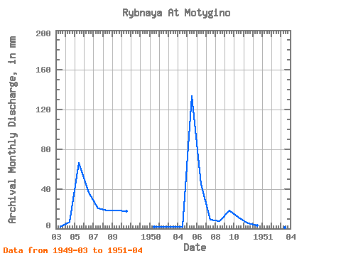
| Year | Jan | Feb | Mar | Apr | May | Jun | Jul | Aug | Sep | Oct | Nov | Dec | Annual | 1949 | 1.71 | 7.09 | 68.21 | 36.37 | 21.38 | 18.98 | 18.52 | 18.47 | 1950 | 1.77 | 1.44 | 1.55 | 1.62 | 138.32 | 44.63 | 9.10 | 7.67 | 18.37 | 11.65 | 5.32 | 3.32 | 242.78 | 1951 | 1.64 | 1.55 | 1.39 | 1.90 |
|---|
 Return to R-Arctic Net Home Page