|
|
|||||||||||||||||
| Point ID: 8227 | Downloads | Plots | Site Data | Code: 8272 |
|
|
|||||||||||||||||
| Download | |
|---|---|
| Site Descriptor Information | Site Time Series Data |
| Link to all available data | |
|
|
| View: | Statistics | Time Series |
| Units: | m3/s |
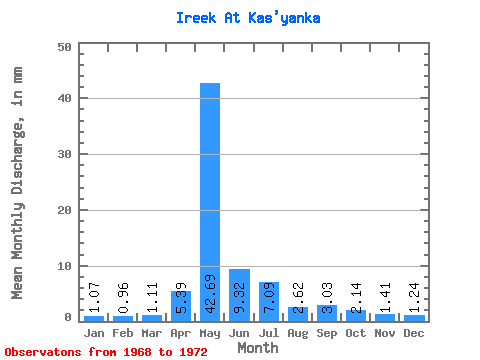
| Statistic | Jan | Feb | Mar | Apr | May | Jun | Jul | Aug | Sep | Oct | Nov | Dec | Annual |
|---|---|---|---|---|---|---|---|---|---|---|---|---|---|
| Mean | 1.06 | 0.97 | 1.11 | 5.39 | 42.68 | 9.32 | 7.09 | 2.62 | 3.03 | 2.15 | 1.41 | 1.23 | 78.74 |
| Standard Deviation | 0.25 | 0.13 | 0.15 | 3.91 | 14.36 | 1.58 | 4.04 | 0.65 | 1.03 | 0.69 | 0.30 | 0.39 | 14.07 |
| Min | 0.73 | 0.78 | 0.91 | 1.12 | 29.03 | 7.54 | 3.23 | 1.70 | 1.89 | 1.70 | 1.12 | 0.85 | 64.02 |
| Max | 1.34 | 1.05 | 1.28 | 9.13 | 62.69 | 11.37 | 12.29 | 3.10 | 4.12 | 3.17 | 1.83 | 1.77 | 92.05 |
| Coefficient of Variation | 0.24 | 0.14 | 0.14 | 0.72 | 0.34 | 0.17 | 0.57 | 0.25 | 0.34 | 0.32 | 0.21 | 0.31 | 0.18 |
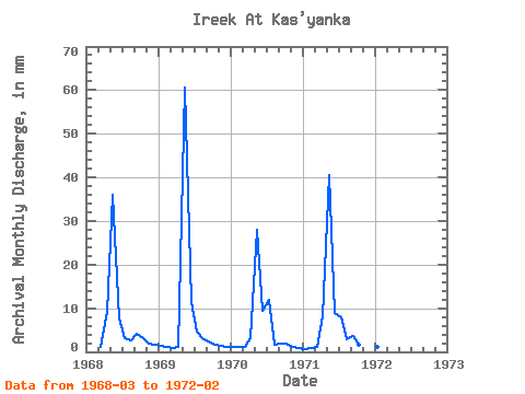
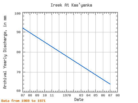
| Year | Jan | Feb | Mar | Apr | May | Jun | Jul | Aug | Sep | Oct | Nov | Dec | Annual | 1968 | 1.28 | 9.13 | 37.07 | 7.54 | 3.23 | 2.62 | 4.12 | 3.17 | 1.83 | 1.77 | 1969 | 1.34 | 1.05 | 0.91 | 1.12 | 62.69 | 11.37 | 4.69 | 3.10 | 2.47 | 1.77 | 1.35 | 1.22 | 92.05 | 1970 | 1.10 | 1.05 | 1.16 | 3.06 | 29.03 | 9.37 | 12.29 | 1.70 | 1.89 | 1.95 | 1.12 | 0.85 | 64.02 | 1971 | 0.73 | 0.78 | 1.10 | 8.25 | 41.94 | 9.01 | 8.16 | 3.04 | 3.65 | 1.70 | 1.35 | 1.10 | 80.16 | 1972 | 1.10 | 1.00 |
|---|
 Return to R-Arctic Net Home Page