|
|
|||||||||||||||||
| Point ID: 8221 | Downloads | Plots | Site Data | Code: 8257 |
|
|
|||||||||||||||||
| Download | |
|---|---|
| Site Descriptor Information | Site Time Series Data |
| Link to all available data | |
|
|
| View: | Statistics | Time Series |
| Units: | m3/s |
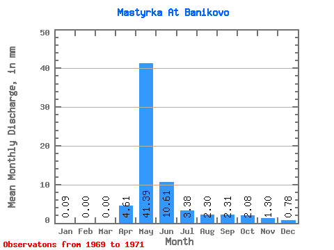
| Statistic | Jan | Feb | Mar | Apr | May | Jun | Jul | Aug | Sep | Oct | Nov | Dec | Annual |
|---|---|---|---|---|---|---|---|---|---|---|---|---|---|
| Mean | 0.07 | 0.00 | 0.00 | 4.61 | 41.38 | 10.62 | 3.39 | 2.28 | 2.31 | 2.08 | 1.30 | 0.76 | 56.17 |
| Standard Deviation | 0.09 | 0.00 | 0.59 | 15.63 | 3.09 | 0.61 | 0.36 | 0.30 | 0.55 | 0.71 | 0.64 | ||
| Min | 0.00 | 0.00 | 0.00 | 4.19 | 30.33 | 7.13 | 2.77 | 1.99 | 2.10 | 1.69 | 0.80 | 0.30 | 56.17 |
| Max | 0.13 | 0.00 | 0.00 | 5.03 | 52.43 | 13.00 | 3.99 | 2.69 | 2.52 | 2.47 | 1.80 | 1.21 | 56.17 |
| Coefficient of Variation | 1.41 | 0.13 | 0.38 | 0.29 | 0.18 | 0.16 | 0.13 | 0.27 | 0.55 | 0.85 |
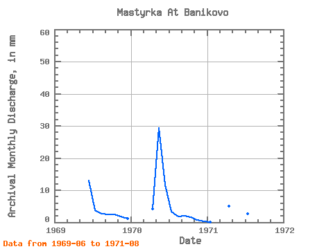
| Year | Jan | Feb | Mar | Apr | May | Jun | Jul | Aug | Sep | Oct | Nov | Dec | Annual | 1969 | 13.00 | 3.99 | 2.69 | 2.52 | 2.47 | 1.80 | 1.21 | 1970 | 0.00 | 0.00 | 0.00 | 4.19 | 30.33 | 11.74 | 3.42 | 1.99 | 2.10 | 1.69 | 0.80 | 0.30 | 56.17 | 1971 | 0.13 | 0.00 | 5.03 | 52.43 | 7.13 | 2.77 | 2.17 |
|---|
 Return to R-Arctic Net Home Page