|
|
|||||||||||||||||
| Point ID: 8179 | Downloads | Plots | Site Data | Code: 8151 |
|
|
|||||||||||||||||
| Download | |
|---|---|
| Site Descriptor Information | Site Time Series Data |
| Link to all available data | |
|
|
| View: | Statistics | Time Series |
| Units: | m3/s |
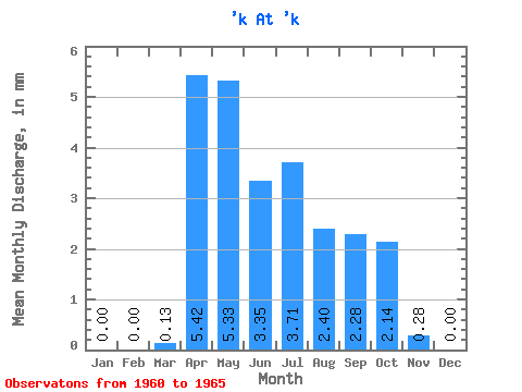
| Statistic | Jan | Feb | Mar | Apr | May | Jun | Jul | Aug | Sep | Oct | Nov | Dec | Annual |
|---|---|---|---|---|---|---|---|---|---|---|---|---|---|
| Mean | 0.00 | 0.00 | 0.13 | 5.42 | 5.33 | 3.35 | 3.71 | 2.40 | 2.28 | 2.13 | 0.28 | 0.00 | 24.90 |
| Standard Deviation | 0.00 | 0.00 | 0.30 | 1.62 | 1.87 | 1.08 | 0.83 | 0.27 | 0.96 | 1.08 | 0.21 | 0.00 | 4.10 |
| Min | 0.00 | 0.00 | 0.00 | 2.69 | 3.22 | 2.17 | 2.82 | 2.10 | 1.56 | 1.07 | 0.00 | 0.00 | 21.29 |
| Max | 0.00 | 0.00 | 0.67 | 6.85 | 7.88 | 5.07 | 4.84 | 2.64 | 3.94 | 4.03 | 0.56 | 0.00 | 31.49 |
| Coefficient of Variation | 2.24 | 0.30 | 0.35 | 0.32 | 0.23 | 0.11 | 0.42 | 0.51 | 0.74 | 0.17 |
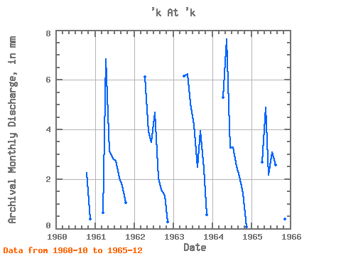
| Year | Jan | Feb | Mar | Apr | May | Jun | Jul | Aug | Sep | Oct | Nov | Dec | Annual | 1960 | 2.33 | 0.39 | 0.00 | 1961 | 0.00 | 0.00 | 0.67 | 6.85 | 3.22 | 2.82 | 2.82 | 2.10 | 1.73 | 1.07 | 0.00 | 0.00 | 21.29 | 1962 | 0.00 | 0.00 | 0.00 | 6.11 | 4.03 | 3.47 | 4.84 | 2.10 | 1.56 | 1.39 | 0.28 | 0.00 | 23.72 | 1963 | 0.00 | 0.00 | 0.00 | 6.16 | 6.45 | 5.07 | 4.30 | 2.55 | 3.94 | 2.51 | 0.56 | 0.00 | 31.49 | 1964 | 0.00 | 0.00 | 0.00 | 5.29 | 7.88 | 3.25 | 3.40 | 2.60 | 2.12 | 1.48 | 0.08 | 0.00 | 25.99 | 1965 | 0.00 | 0.00 | 0.00 | 2.69 | 5.06 | 2.17 | 3.18 | 2.64 | 2.04 | 4.03 | 0.38 | 0.00 | 22.02 |
|---|
 Return to R-Arctic Net Home Page