|
|
|||||||||||||||||
| Point ID: 8143 | Downloads | Plots | Site Data | Code: 7199 |
|
|
|||||||||||||||||
| Download | |
|---|---|
| Site Descriptor Information | Site Time Series Data |
| Link to all available data | |
|
|
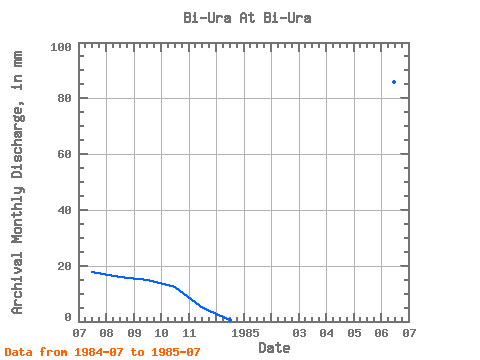
| View: | Statistics | Time Series |
| Units: | m3/s |
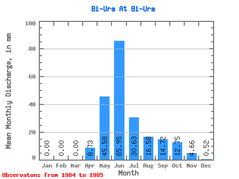
| Statistic | Jan | Feb | Mar | Apr | May | Jun | Jul | Aug | Sep | Oct | Nov | Dec | Annual |
|---|---|---|---|---|---|---|---|---|---|---|---|---|---|
| Mean | 0.00 | 0.00 | 0.00 | 8.73 | 45.58 | 85.95 | 30.63 | 16.58 | 14.72 | 12.75 | 4.66 | 0.52 | |
| Standard Deviation | 17.33 | ||||||||||||
| Min | 0.00 | 0.00 | 0.00 | 8.73 | 45.58 | 85.95 | 18.37 | 16.58 | 14.72 | 12.75 | 4.66 | 0.52 | |
| Max | 0.00 | 0.00 | 0.00 | 8.73 | 45.58 | 85.95 | 42.89 | 16.58 | 14.72 | 12.75 | 4.66 | 0.52 | |
| Coefficient of Variation | 0.57 |
| Year | Jan | Feb | Mar | Apr | May | Jun | Jul | Aug | Sep | Oct | Nov | Dec | Annual | 1984 | 18.37 | 16.58 | 14.72 | 12.75 | 4.66 | 0.52 | 1985 | 0.00 | 0.00 | 0.00 | 8.73 | 45.58 | 85.95 | 42.89 |
|---|
 Return to R-Arctic Net Home Page