|
|
|||||||||||||||||
| Point ID: 8137 | Downloads | Plots | Site Data | Code: 7105 |
|
|
|||||||||||||||||
| Download | |
|---|---|
| Site Descriptor Information | Site Time Series Data |
| Link to all available data | |
|
|
| View: | Statistics | Time Series |
| Units: | m3/s |
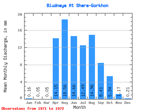
| Statistic | Jan | Feb | Mar | Apr | May | Jun | Jul | Aug | Sep | Oct | Nov | Dec | Annual |
|---|---|---|---|---|---|---|---|---|---|---|---|---|---|
| Mean | 0.16 | 0.05 | 0.05 | 14.15 | 18.55 | 14.66 | 12.49 | 14.96 | 8.41 | 5.34 | 1.17 | 0.21 | 89.84 |
| Standard Deviation | 0.12 | 0.04 | 0.02 | 8.62 | 13.61 | 14.92 | 2.12 | 5.79 | 0.50 | 1.34 | 0.58 | 0.21 | 47.83 |
| Min | 0.07 | 0.02 | 0.03 | 8.06 | 8.93 | 4.11 | 10.99 | 10.86 | 8.06 | 4.40 | 0.76 | 0.06 | 56.03 |
| Max | 0.25 | 0.08 | 0.06 | 20.25 | 28.18 | 25.21 | 13.99 | 19.05 | 8.77 | 6.29 | 1.59 | 0.35 | 123.66 |
| Coefficient of Variation | 0.77 | 0.88 | 0.39 | 0.61 | 0.73 | 1.02 | 0.17 | 0.39 | 0.06 | 0.25 | 0.50 | 1.01 | 0.53 |
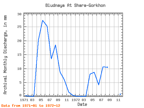
| Year | Jan | Feb | Mar | Apr | May | Jun | Jul | Aug | Sep | Oct | Nov | Dec | Annual | 1971 | 0.25 | 0.08 | 0.06 | 20.25 | 28.18 | 25.21 | 13.99 | 19.05 | 8.77 | 6.29 | 1.59 | 0.35 | 123.66 | 1972 | 0.07 | 0.02 | 0.03 | 8.06 | 8.93 | 4.11 | 10.99 | 10.86 | 8.06 | 4.40 | 0.76 | 0.06 | 56.03 |
|---|
 Return to R-Arctic Net Home Page