|
|
|||||||||||||||||
| Point ID: 8123 | Downloads | Plots | Site Data | Code: 1606 |
|
|
|||||||||||||||||
| Download | |
|---|---|
| Site Descriptor Information | Site Time Series Data |
| Link to all available data | |
|
|
| View: | Statistics | Time Series |
| Units: | m3/s |
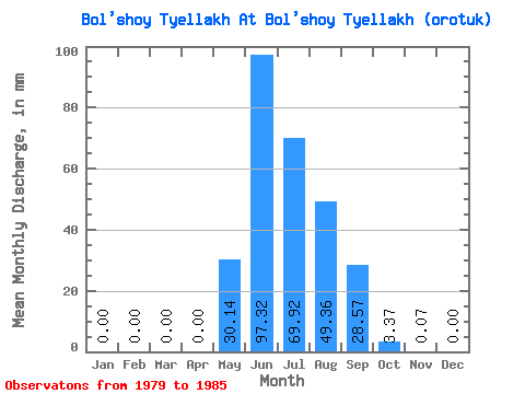
| Statistic | Jan | Feb | Mar | Apr | May | Jun | Jul | Aug | Sep | Oct | Nov | Dec | Annual |
|---|---|---|---|---|---|---|---|---|---|---|---|---|---|
| Mean | 0.00 | 0.00 | 0.00 | 0.00 | 30.14 | 97.33 | 69.91 | 49.35 | 28.57 | 3.37 | 0.07 | 0.00 | 277.86 |
| Standard Deviation | 0.00 | 0.00 | 0.00 | 0.00 | 14.69 | 56.73 | 23.89 | 16.27 | 16.17 | 1.92 | 0.05 | 0.00 | 60.94 |
| Min | 0.00 | 0.00 | 0.00 | 0.00 | 7.18 | 44.36 | 32.19 | 29.10 | 12.88 | 2.14 | 0.01 | 0.00 | 199.65 |
| Max | 0.00 | 0.00 | 0.00 | 0.01 | 52.53 | 181.69 | 100.94 | 71.33 | 56.58 | 7.21 | 0.14 | 0.00 | 337.66 |
| Coefficient of Variation | 2.45 | 0.49 | 0.58 | 0.34 | 0.33 | 0.57 | 0.57 | 0.75 | 0.22 |
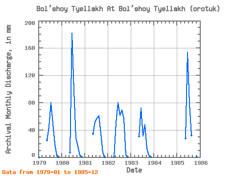
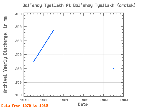
| Year | Jan | Feb | Mar | Apr | May | Jun | Jul | Aug | Sep | Oct | Nov | Dec | Annual | 1979 | 0.00 | 0.00 | 0.00 | 0.00 | 25.57 | 44.36 | 82.92 | 50.98 | 19.94 | 2.14 | 0.04 | 0.00 | 224.00 | 1980 | 0.00 | 0.00 | 0.00 | 0.00 | 7.18 | 181.69 | 100.94 | 29.10 | 16.00 | 2.34 | 0.01 | 0.00 | 337.66 | 1981 | 0.00 | 0.00 | 0.00 | 0.00 | 35.28 | 52.09 | 58.97 | 62.31 | 34.64 | 7.21 | 0.10 | 0.00 | 248.94 | 1982 | 0.00 | 0.00 | 0.00 | 0.01 | 52.53 | 79.75 | 63.09 | 71.33 | 56.58 | 3.12 | 0.14 | 0.00 | 325.13 | 1983 | 0.00 | 0.00 | 0.00 | 0.00 | 31.41 | 72.28 | 32.19 | 49.18 | 12.88 | 2.50 | 0.02 | 0.00 | 199.65 | 1985 | 0.00 | 0.00 | 0.00 | 0.00 | 28.84 | 153.78 | 81.37 | 33.22 | 31.40 | 2.94 | 0.11 | 0.00 | 331.75 |
|---|
 Return to R-Arctic Net Home Page