|
|
|||||||||||||||||
| Point ID: 8091 | Downloads | Plots | Site Data | Code: 1517 |
|
|
|||||||||||||||||
| Download | |
|---|---|
| Site Descriptor Information | Site Time Series Data |
| Link to all available data | |
|
|
| View: | Statistics | Time Series |
| Units: | m3/s |
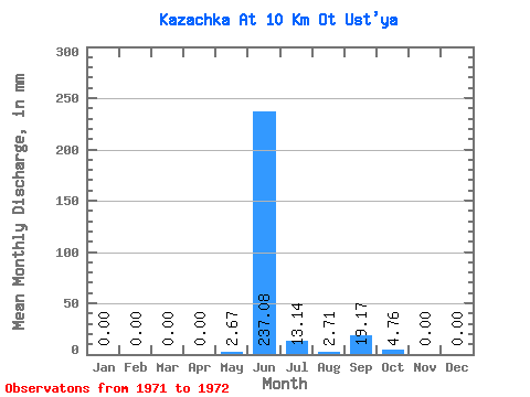
| Statistic | Jan | Feb | Mar | Apr | May | Jun | Jul | Aug | Sep | Oct | Nov | Dec | Annual |
|---|---|---|---|---|---|---|---|---|---|---|---|---|---|
| Mean | 0.00 | 0.00 | 0.00 | 0.00 | 2.67 | 237.08 | 13.14 | 2.71 | 19.17 | 4.76 | 0.00 | 0.00 | 282.87 |
| Standard Deviation | 0.00 | 0.00 | 0.00 | 0.00 | 3.77 | 11.99 | 4.04 | 2.10 | 20.86 | 4.04 | 0.00 | 0.00 | 39.10 |
| Min | 0.00 | 0.00 | 0.00 | 0.00 | 0.00 | 228.60 | 10.29 | 1.22 | 4.42 | 1.91 | 0.00 | 0.00 | 255.22 |
| Max | 0.00 | 0.00 | 0.00 | 0.00 | 5.33 | 245.56 | 16.00 | 4.19 | 33.92 | 7.62 | 0.00 | 0.00 | 310.51 |
| Coefficient of Variation | 1.41 | 0.05 | 0.31 | 0.78 | 1.09 | 0.85 | 0.14 |
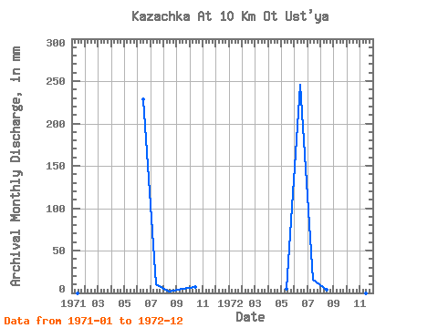
| Year | Jan | Feb | Mar | Apr | May | Jun | Jul | Aug | Sep | Oct | Nov | Dec | Annual | 1971 | 0.00 | 0.00 | 0.00 | 0.00 | 0.00 | 228.60 | 10.29 | 1.22 | 4.42 | 7.62 | 0.00 | 0.00 | 255.22 | 1972 | 0.00 | 0.00 | 0.00 | 0.00 | 5.33 | 245.56 | 16.00 | 4.19 | 33.92 | 1.91 | 0.00 | 0.00 | 310.51 |
|---|
 Return to R-Arctic Net Home Page