|
|
|||||||||||||||||
| Point ID: 8078 | Downloads | Plots | Site Data | Code: 1443 |
|
|
|||||||||||||||||
| Download | |
|---|---|
| Site Descriptor Information | Site Time Series Data |
| Link to all available data | |
|
|
| View: | Statistics | Time Series |
| Units: | m3/s |
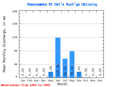
| Statistic | Jan | Feb | Mar | Apr | May | Jun | Jul | Aug | Sep | Oct | Nov | Dec | Annual |
|---|---|---|---|---|---|---|---|---|---|---|---|---|---|
| Mean | 0.00 | 0.00 | 0.00 | 0.00 | 17.27 | 118.36 | 56.51 | 78.43 | 17.40 | 0.96 | 0.00 | 0.00 | 288.17 |
| Standard Deviation | 0.00 | 0.00 | 0.00 | 0.00 | 17.16 | 52.47 | 28.19 | 40.64 | 11.83 | 0.93 | 0.00 | 0.00 | 82.60 |
| Min | 0.00 | 0.00 | 0.00 | 0.00 | 0.00 | 71.77 | 19.08 | 44.52 | 5.02 | 0.15 | 0.00 | 0.00 | 204.81 |
| Max | 0.00 | 0.00 | 0.00 | 0.00 | 42.35 | 200.88 | 97.25 | 146.29 | 35.15 | 2.51 | 0.00 | 0.00 | 427.11 |
| Coefficient of Variation | 0.99 | 0.44 | 0.50 | 0.52 | 0.68 | 0.96 | 0.29 |
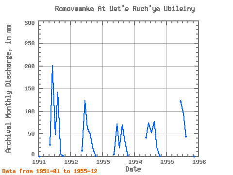
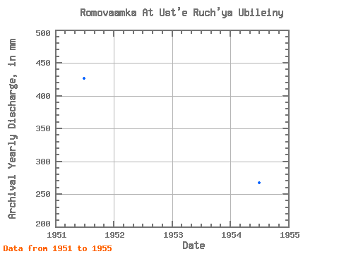
| Year | Jan | Feb | Mar | Apr | May | Jun | Jul | Aug | Sep | Oct | Nov | Dec | Annual | 1951 | 0.00 | 0.00 | 0.00 | 0.00 | 26.11 | 200.88 | 49.04 | 146.29 | 5.02 | 0.74 | 0.00 | 0.00 | 427.11 | 1952 | 0.00 | 0.00 | 0.00 | 0.00 | 13.05 | 123.61 | 63.77 | 50.05 | 18.63 | 1.00 | 0.00 | 0.00 | 269.90 | 1953 | 0.00 | 0.00 | 0.00 | 0.00 | 4.85 | 71.77 | 19.08 | 71.64 | 35.15 | 2.51 | 0.00 | 0.00 | 204.81 | 1954 | 0.00 | 0.00 | 0.00 | 0.00 | 42.35 | 73.71 | 53.39 | 79.67 | 19.93 | 0.40 | 0.00 | 0.00 | 267.67 | 1955 | 0.00 | 0.00 | 0.00 | 0.00 | 0.00 | 121.82 | 97.25 | 44.52 | 8.26 | 0.15 | 0.00 | 0.00 | 271.37 |
|---|
 Return to R-Arctic Net Home Page