|
|
|||||||||||||||||
| Point ID: 8076 | Downloads | Plots | Site Data | Code: 1423 |
|
|
|||||||||||||||||
| Download | |
|---|---|
| Site Descriptor Information | Site Time Series Data |
| Link to all available data | |
|
|
| View: | Statistics | Time Series |
| Units: | m3/s |
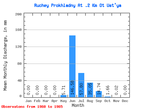
| Statistic | Jan | Feb | Mar | Apr | May | Jun | Jul | Aug | Sep | Oct | Nov | Dec | Annual |
|---|---|---|---|---|---|---|---|---|---|---|---|---|---|
| Mean | 0.00 | 0.00 | 0.00 | 0.00 | 5.71 | 146.59 | 57.80 | 35.05 | 14.73 | 1.66 | 0.01 | 0.00 | 264.92 |
| Standard Deviation | 0.00 | 0.00 | 0.00 | 0.00 | 8.97 | 47.64 | 47.05 | 13.18 | 14.64 | 1.31 | 0.03 | 0.00 | 62.94 |
| Min | 0.00 | 0.00 | 0.00 | 0.00 | 0.00 | 86.65 | 25.25 | 16.32 | 5.18 | 0.36 | 0.00 | 0.00 | 192.59 |
| Max | 0.00 | 0.00 | 0.00 | 0.00 | 21.42 | 200.20 | 140.79 | 45.91 | 42.71 | 3.32 | 0.07 | 0.00 | 331.20 |
| Coefficient of Variation | 1.57 | 0.33 | 0.81 | 0.38 | 0.99 | 0.79 | 2.24 | 0.24 |
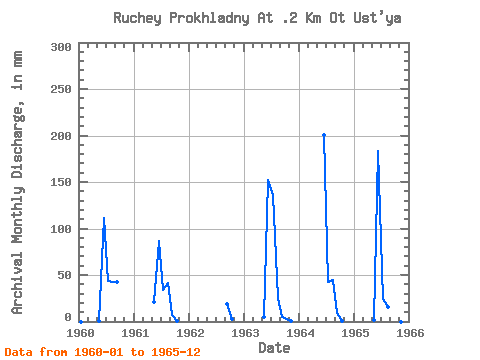
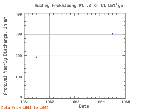
| Year | Jan | Feb | Mar | Apr | May | Jun | Jul | Aug | Sep | Oct | Nov | Dec | Annual | 1960 | 0.00 | 0.00 | 0.00 | 0.00 | 0.33 | 111.10 | 44.66 | 44.39 | 42.71 | 1961 | 0.00 | 0.00 | 0.00 | 0.00 | 21.42 | 86.65 | 34.69 | 42.59 | 6.91 | 0.74 | 0.00 | 0.00 | 192.59 | 1962 | 19.01 | 2.81 | 0.00 | 0.00 | 1963 | 0.00 | 0.00 | 0.00 | 0.00 | 4.59 | 152.06 | 140.79 | 26.02 | 5.18 | 3.32 | 0.07 | 0.00 | 331.20 | 1964 | 0.00 | 0.00 | 0.00 | 0.00 | 0.00 | 200.20 | 43.61 | 45.91 | 9.13 | 1.10 | 0.00 | 0.00 | 301.40 | 1965 | 0.00 | 0.00 | 0.00 | 0.00 | 2.22 | 182.92 | 25.25 | 16.32 | 5.43 | 0.36 | 0.00 | 0.00 | 234.47 |
|---|
 Return to R-Arctic Net Home Page