|
|
|||||||||||||||||
| Point ID: 806 | Downloads | Plots | Site Data | Code: 07NB007 |
|
|
|||||||||||||||||
| Download | |
|---|---|
| Site Descriptor Information | Site Time Series Data |
| Link to all available data | |
|
|
| View: | Statistics | Time Series |
| Units: | m3/s |
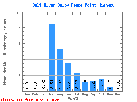
| Statistic | Jan | Feb | Mar | Apr | May | Jun | Jul | Aug | Sep | Oct | Nov | Dec | Annual |
|---|---|---|---|---|---|---|---|---|---|---|---|---|---|
| Mean | 0.00 | 0.00 | 0.00 | 5.42 | 3.41 | 2.29 | 1.42 | 0.73 | 0.82 | 0.93 | 0.31 | 0.03 | 15.36 |
| Standard Deviation | 0.00 | 0.00 | 0.00 | 6.50 | 3.08 | 3.81 | 1.47 | 0.90 | 0.86 | 1.02 | 0.26 | 0.03 | 10.55 |
| Min | 0.00 | 0.00 | 0.00 | 0.05 | 0.08 | 0.06 | 0.08 | 0.02 | 0.01 | 0.04 | 0.04 | 0.00 | 2.36 |
| Max | 0.01 | 0.00 | 0.00 | 16.30 | 9.64 | 11.50 | 3.91 | 2.61 | 1.96 | 2.94 | 0.69 | 0.07 | 32.10 |
| Coefficient of Variation | 1.27 | 2.83 | 1.20 | 0.90 | 1.66 | 1.04 | 1.24 | 1.06 | 1.10 | 0.84 | 0.92 | 0.69 |
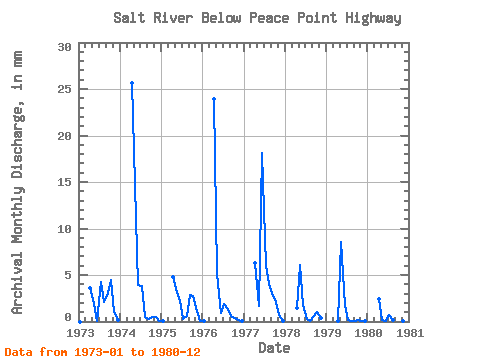
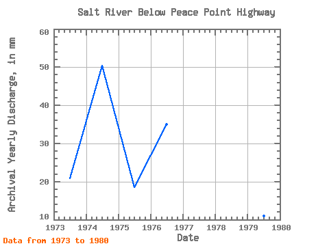
| Year | Jan | Feb | Mar | Apr | May | Jun | Jul | Aug | Sep | Oct | Nov | Dec | Annual | 1973 | 0.00 | 0.00 | 0.00 | 2.27 | 1.20 | 0.06 | 2.81 | 1.40 | 1.96 | 2.94 | 0.68 | 0.07 | 13.30 | 1974 | 0.00 | 0.00 | 0.00 | 16.30 | 9.64 | 2.48 | 2.47 | 0.33 | 0.20 | 0.28 | 0.28 | 0.06 | 32.10 | 1975 | 0.01 | 0.00 | 0.00 | 3.06 | 2.31 | 1.40 | 0.20 | 0.41 | 1.83 | 1.76 | 0.69 | 0.05 | 11.74 | 1976 | 0.01 | 0.00 | 0.00 | 15.21 | 3.37 | 0.56 | 1.27 | 0.91 | 0.38 | 0.27 | 0.11 | 0.02 | 22.24 | 1977 | 0.00 | 0.00 | 0.00 | 4.00 | 1.10 | 11.50 | 3.91 | 2.61 | 1.75 | 1.38 | 0.42 | 0.04 | 26.82 | 1978 | 0.00 | 0.00 | 0.00 | 0.90 | 3.98 | 1.11 | 0.18 | 0.04 | 0.37 | 0.68 | 0.23 | 0.00 | 7.44 | 1979 | 0.00 | 0.00 | 0.00 | 0.05 | 5.61 | 1.12 | 0.08 | 0.02 | 0.01 | 0.08 | 0.05 | 0.01 | 6.93 | 1980 | 0.00 | 0.00 | 0.00 | 1.57 | 0.08 | 0.06 | 0.42 | 0.08 | 0.04 | 0.04 | 0.04 | 0.00 | 2.36 |
|---|
 Return to R-Arctic Net Home Page