|
|
|||||||||||||||||
| Point ID: 8050 | Downloads | Plots | Site Data | Code: 1155 |
|
|
|||||||||||||||||
| Download | |
|---|---|
| Site Descriptor Information | Site Time Series Data |
| Link to all available data | |
|
|
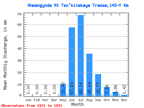
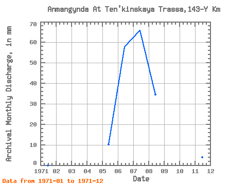
| View: | Statistics | Time Series |
| Units: | m3/s |
| Statistic | Jan | Feb | Mar | Apr | May | Jun | Jul | Aug | Sep | Oct | Nov | Dec | Annual |
|---|---|---|---|---|---|---|---|---|---|---|---|---|---|
| Mean | 0.00 | 0.00 | 0.00 | 0.00 | 10.48 | 57.83 | 68.13 | 35.64 | 18.77 | 7.86 | 3.85 | 1.42 | 202.94 |
| Standard Deviation | |||||||||||||
| Min | 0.00 | 0.00 | 0.00 | 0.00 | 10.48 | 57.83 | 68.13 | 35.64 | 18.77 | 7.86 | 3.85 | 1.42 | 202.94 |
| Max | 0.00 | 0.00 | 0.00 | 0.00 | 10.48 | 57.83 | 68.13 | 35.64 | 18.77 | 7.86 | 3.85 | 1.42 | 202.94 |
| Coefficient of Variation |
| Year | Jan | Feb | Mar | Apr | May | Jun | Jul | Aug | Sep | Oct | Nov | Dec | Annual | 1971 | 0.00 | 0.00 | 0.00 | 0.00 | 10.48 | 57.83 | 68.13 | 35.64 | 18.77 | 7.86 | 3.85 | 1.42 | 202.94 |
|---|
 Return to R-Arctic Net Home Page