|
|
|||||||||||||||||
| Point ID: 8048 | Downloads | Plots | Site Data | Code: 1149 |
|
|
|||||||||||||||||
| Download | |
|---|---|
| Site Descriptor Information | Site Time Series Data |
| Link to all available data | |
|
|
| View: | Statistics | Time Series |
| Units: | m3/s |
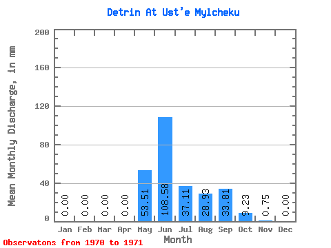
| Statistic | Jan | Feb | Mar | Apr | May | Jun | Jul | Aug | Sep | Oct | Nov | Dec | Annual |
|---|---|---|---|---|---|---|---|---|---|---|---|---|---|
| Mean | 0.00 | 0.00 | 0.00 | 0.00 | 53.50 | 108.58 | 37.10 | 28.92 | 33.81 | 9.22 | 0.75 | 0.00 | 271.68 |
| Standard Deviation | 0.00 | 0.00 | 0.00 | 0.00 | 27.02 | 69.65 | 7.87 | 6.90 | 13.12 | 0.76 | 0.08 | 0.00 | 72.61 |
| Min | 0.00 | 0.00 | 0.00 | 0.00 | 34.40 | 59.33 | 31.54 | 24.04 | 24.54 | 8.69 | 0.69 | 0.00 | 220.34 |
| Max | 0.00 | 0.00 | 0.00 | 0.00 | 72.60 | 157.82 | 42.67 | 33.80 | 43.09 | 9.76 | 0.81 | 0.00 | 323.02 |
| Coefficient of Variation | 0.51 | 0.64 | 0.21 | 0.24 | 0.39 | 0.08 | 0.11 | 0.27 |
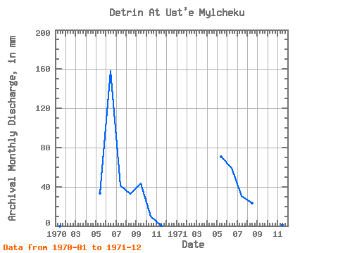
| Year | Jan | Feb | Mar | Apr | May | Jun | Jul | Aug | Sep | Oct | Nov | Dec | Annual | 1970 | 0.00 | 0.00 | 0.00 | 0.00 | 34.40 | 157.82 | 42.67 | 33.80 | 43.09 | 9.76 | 0.69 | 0.00 | 323.02 | 1971 | 0.00 | 0.00 | 0.00 | 0.00 | 72.60 | 59.33 | 31.54 | 24.04 | 24.54 | 8.69 | 0.81 | 0.00 | 220.34 |
|---|
 Return to R-Arctic Net Home Page