|
|
|||||||||||||||||
| Point ID: 8017 | Downloads | Plots | Site Data | Code: 3850 |
|
|
|||||||||||||||||
| Download | |
|---|---|
| Site Descriptor Information | Site Time Series Data |
| Link to all available data | |
|
|
| View: | Statistics | Time Series |
| Units: | m3/s |
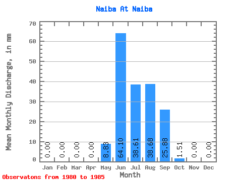
| Statistic | Jan | Feb | Mar | Apr | May | Jun | Jul | Aug | Sep | Oct | Nov | Dec | Annual |
|---|---|---|---|---|---|---|---|---|---|---|---|---|---|
| Mean | 0.00 | 0.00 | 0.00 | 0.00 | 8.83 | 64.10 | 38.60 | 38.67 | 25.87 | 1.51 | 0.00 | 0.00 | 177.34 |
| Standard Deviation | 0.00 | 0.00 | 0.00 | 0.00 | 17.43 | 23.25 | 18.78 | 16.32 | 13.62 | 1.88 | 0.00 | 0.00 | 33.24 |
| Min | 0.00 | 0.00 | 0.00 | 0.00 | 0.00 | 34.47 | 11.58 | 7.53 | 9.25 | 0.00 | 0.00 | 0.00 | 126.37 |
| Max | 0.00 | 0.00 | 0.00 | 0.00 | 43.57 | 103.26 | 65.28 | 52.69 | 38.39 | 4.20 | 0.00 | 0.00 | 214.66 |
| Coefficient of Variation | 1.97 | 0.36 | 0.49 | 0.42 | 0.53 | 1.24 | 0.19 |
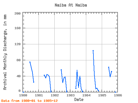
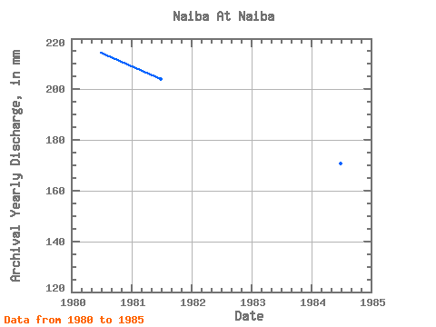
| Year | Jan | Feb | Mar | Apr | May | Jun | Jul | Aug | Sep | Oct | Nov | Dec | Annual | 1980 | 0.00 | 0.00 | 0.00 | 0.00 | 0.00 | 74.96 | 65.28 | 50.23 | 24.80 | 0.00 | 0.00 | 0.00 | 214.66 | 1981 | 0.00 | 0.00 | 0.00 | 0.00 | 43.57 | 34.47 | 45.60 | 43.43 | 38.39 | 0.10 | 0.00 | 0.00 | 204.24 | 1982 | 0.00 | 0.00 | 0.00 | 0.00 | 0.00 | 55.34 | 24.03 | 37.06 | 37.41 | 0.45 | 0.00 | 0.00 | 154.54 | 1983 | 0.00 | 0.00 | 0.00 | 0.00 | 9.41 | 54.50 | 11.58 | 41.11 | 9.25 | 0.71 | 0.00 | 0.00 | 126.37 | 1984 | 0.00 | 0.00 | 0.00 | 0.00 | 0.00 | 103.26 | 46.32 | 7.53 | 9.67 | 3.62 | 0.00 | 0.00 | 171.02 | 1985 | 0.00 | 0.00 | 0.00 | 0.00 | 0.00 | 62.07 | 38.80 | 52.69 | 35.73 | 4.20 | 0.00 | 0.00 | 193.20 |
|---|
 Return to R-Arctic Net Home Page