|
|
|||||||||||||||||
| Point ID: 8002 | Downloads | Plots | Site Data | Code: 3666 |
|
|
|||||||||||||||||
| Download | |
|---|---|
| Site Descriptor Information | Site Time Series Data |
| Link to all available data | |
|
|
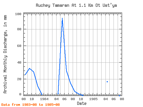
| View: | Statistics | Time Series |
| Units: | m3/s |
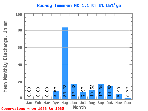
| Statistic | Jan | Feb | Mar | Apr | May | Jun | Jul | Aug | Sep | Oct | Nov | Dec | Annual |
|---|---|---|---|---|---|---|---|---|---|---|---|---|---|
| Mean | 0.00 | 0.00 | 0.00 | 9.57 | 83.21 | 17.43 | 7.97 | 10.52 | 17.36 | 14.82 | 5.40 | 0.93 | 151.07 |
| Standard Deviation | 0.00 | 0.00 | 0.00 | 10.04 | 18.94 | 17.67 | 11.27 | 13.80 | 21.71 | 20.51 | 7.64 | 1.31 | |
| Min | 0.00 | 0.00 | 0.00 | 2.47 | 69.82 | 4.94 | 0.00 | 0.00 | 2.01 | 0.32 | 0.00 | 0.00 | 151.07 |
| Max | 0.00 | 0.00 | 0.00 | 16.66 | 96.60 | 29.93 | 15.94 | 26.14 | 32.71 | 29.33 | 10.80 | 1.85 | 151.07 |
| Coefficient of Variation | 1.05 | 0.23 | 1.01 | 1.41 | 1.31 | 1.25 | 1.38 | 1.41 | 1.41 |
| Year | Jan | Feb | Mar | Apr | May | Jun | Jul | Aug | Sep | Oct | Nov | Dec | Annual | 1983 | 26.14 | 32.71 | 29.33 | 10.80 | 1.85 | 1984 | 0.00 | 0.00 | 0.00 | 2.47 | 96.60 | 29.93 | 15.94 | 5.42 | 2.01 | 0.32 | 0.00 | 0.00 | 151.07 | 1985 | 0.00 | 0.00 | 0.00 | 16.66 | 69.82 | 4.94 | 0.00 | 0.00 |
|---|
 Return to R-Arctic Net Home Page