|
|
|||||||||||||||||
| Point ID: 8 | Downloads | Plots | Site Data | Code: 05AA008 |
|
|
|||||||||||||||||
| Download | |
|---|---|
| Site Descriptor Information | Site Time Series Data |
| Link to all available data | |
|
|
| View: | Statistics | Time Series |
| Units: | m3/s |
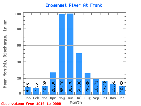
| Statistic | Jan | Feb | Mar | Apr | May | Jun | Jul | Aug | Sep | Oct | Nov | Dec | Annual |
|---|---|---|---|---|---|---|---|---|---|---|---|---|---|
| Mean | 9.65 | 8.03 | 10.08 | 26.90 | 98.18 | 98.70 | 50.35 | 25.84 | 18.71 | 17.18 | 13.53 | 10.83 | 376.33 |
| Standard Deviation | 2.57 | 2.18 | 4.07 | 14.08 | 36.38 | 40.40 | 18.88 | 10.53 | 8.41 | 7.58 | 6.61 | 4.19 | 99.86 |
| Min | 5.59 | 4.22 | 5.87 | 5.96 | 33.48 | 30.15 | 14.91 | 11.07 | 9.37 | 8.82 | 7.12 | 4.89 | 187.35 |
| Max | 15.58 | 14.49 | 29.30 | 69.29 | 196.21 | 202.10 | 98.11 | 80.87 | 56.72 | 49.19 | 41.90 | 24.39 | 605.55 |
| Coefficient of Variation | 0.27 | 0.27 | 0.40 | 0.52 | 0.37 | 0.41 | 0.38 | 0.41 | 0.45 | 0.44 | 0.49 | 0.39 | 0.27 |
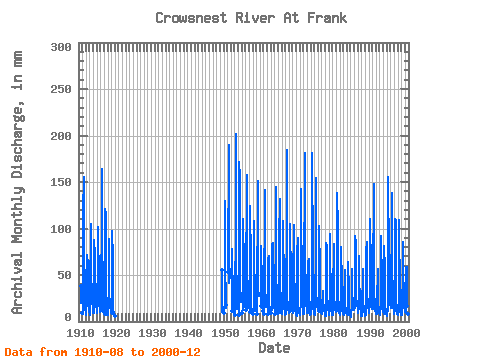
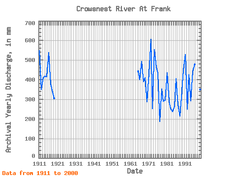
| Year | Jan | Feb | Mar | Apr | May | Jun | Jul | Aug | Sep | Oct | Nov | Dec | Annual | 1910 | 20.42 | 20.40 | 39.44 | 1911 | 9.41 | 7.91 | 10.94 | 40.61 | 120.64 | 155.26 | 55.75 | 41.23 | 55.62 | 26.25 | 12.45 | 11.87 | 547.48 | 1912 | 8.62 | 7.07 | 6.96 | 35.29 | 73.58 | 67.37 | 67.61 | 29.50 | 17.32 | 14.05 | 13.73 | 10.14 | 349.97 | 1913 | 9.88 | 7.07 | 6.70 | 45.81 | 88.16 | 104.58 | 48.99 | 33.41 | 21.88 | 20.75 | 15.40 | 9.61 | 411.62 | 1914 | 12.06 | 8.34 | 9.81 | 43.31 | 90.81 | 71.22 | 44.28 | 26.25 | 22.45 | 41.16 | 30.86 | 18.36 | 417.68 | 1915 | 12.66 | 9.12 | 9.81 | 42.66 | 104.73 | 81.48 | 62.31 | 32.41 | 17.19 | 19.62 | 14.95 | 10.21 | 415.66 | 1916 | 10.14 | 10.69 | 19.42 | 54.15 | 92.80 | 164.25 | 98.11 | 33.74 | 22.20 | 15.05 | 10.59 | 8.95 | 539.61 | 1917 | 8.48 | 7.49 | 6.96 | 7.57 | 124.62 | 114.84 | 45.14 | 23.27 | 15.46 | 11.20 | 8.66 | 7.29 | 379.66 | 1918 | 10.80 | 7.07 | 8.82 | 42.86 | 82.20 | 89.18 | 32.22 | 19.82 | 14.69 | 16.64 | 11.80 | 9.35 | 345.09 | 1919 | 10.54 | 7.43 | 8.62 | 39.46 | 100.09 | 67.37 | 29.56 | 12.86 | 9.37 | 8.88 | 7.19 | 4.89 | 305.50 | 1920 | 5.59 | 5.89 | 6.54 | 1949 | 55.56 | 14.91 | 11.07 | 12.06 | 10.47 | 1950 | 9.35 | 22.39 | 116.00 | 129.60 | 61.85 | 23.80 | 14.82 | 18.10 | 1951 | 53.06 | 196.21 | 107.14 | 78.88 | 42.49 | 56.72 | 49.19 | 1952 | 11.40 | 69.29 | 80.21 | 60.95 | 38.31 | 21.74 | 13.92 | 10.94 | 1953 | 7.49 | 18.03 | 113.35 | 202.10 | 70.26 | 30.56 | 18.99 | 15.18 | 1954 | 7.29 | 15.46 | 177.65 | 154.62 | 80.21 | 35.53 | 27.33 | 22.87 | 1955 | 9.48 | 13.35 | 66.29 | 110.35 | 58.47 | 24.06 | 15.46 | 18.49 | 1956 | 12.79 | 33.43 | 162.40 | 112.28 | 63.44 | 27.44 | 17.00 | 15.84 | 1957 | 10.14 | 19.12 | 127.93 | 61.34 | 28.37 | 15.51 | 11.80 | 12.79 | 1958 | 8.29 | 13.09 | 111.36 | 61.27 | 41.23 | 19.62 | 13.47 | 13.06 | 1959 | 8.29 | 32.53 | 132.57 | 151.41 | 66.95 | 30.89 | 30.67 | 29.23 | 1960 | 16.84 | 38.17 | 78.88 | 81.48 | 39.38 | 24.79 | 15.65 | 11.34 | 1961 | 8.82 | 14.69 | 146.50 | 122.54 | 39.77 | 21.01 | 16.10 | 21.15 | 1962 | 8.35 | 38.24 | 68.94 | 69.93 | 32.81 | 18.63 | 14.37 | 12.86 | 1963 | 9.15 | 14.95 | 57.41 | 83.41 | 86.84 | 25.12 | 18.54 | 16.50 | 1964 | 8.42 | 14.95 | 110.70 | 144.36 | 55.35 | 25.72 | 18.09 | 16.50 | 11.74 | 8.88 | 1965 | 8.42 | 7.55 | 9.35 | 26.63 | 91.48 | 131.53 | 61.38 | 36.26 | 26.63 | 22.27 | 13.02 | 9.28 | 443.00 | 1966 | 8.48 | 7.85 | 13.06 | 33.55 | 112.03 | 98.80 | 46.87 | 26.65 | 19.05 | 13.92 | 11.48 | 9.35 | 399.97 | 1967 | 7.62 | 7.49 | 8.62 | 13.09 | 125.28 | 184.13 | 68.28 | 26.71 | 16.04 | 13.32 | 12.32 | 10.94 | 493.06 | 1968 | 10.28 | 8.46 | 10.28 | 12.06 | 98.11 | 105.22 | 45.80 | 25.98 | 22.07 | 24.39 | 15.78 | 11.87 | 389.16 | 1969 | 12.73 | 8.58 | 9.68 | 49.85 | 99.43 | 103.94 | 63.04 | 22.14 | 14.18 | 12.06 | 8.79 | 7.22 | 410.84 | 1970 | 6.76 | 5.85 | 5.87 | 5.96 | 76.23 | 89.82 | 35.99 | 16.64 | 13.35 | 12.53 | 8.79 | 9.61 | 286.65 | 1971 | 7.16 | 8.46 | 7.22 | 21.81 | 147.16 | 112.28 | 51.57 | 23.60 | 17.90 | 15.38 | 12.06 | 9.88 | 432.84 | 1972 | 8.48 | 7.43 | 22.41 | 31.89 | 187.59 | 177.08 | 64.03 | 38.91 | 23.10 | 18.76 | 14.82 | 13.19 | 605.55 | 1973 | 9.74 | 8.34 | 9.21 | 11.42 | 65.96 | 66.72 | 28.97 | 16.64 | 12.38 | 8.82 | 8.15 | 7.22 | 253.04 | 1974 | 11.14 | 7.61 | 9.81 | 34.26 | 149.15 | 181.57 | 70.26 | 34.07 | 20.53 | 14.98 | 11.48 | 10.08 | 553.80 | 1975 | 8.35 | 6.34 | 7.29 | 10.27 | 93.47 | 154.62 | 75.57 | 31.16 | 20.47 | 16.64 | 17.00 | 24.39 | 464.42 | 1976 | 15.58 | 10.57 | 10.80 | 31.50 | 106.06 | 60.89 | 46.07 | 80.87 | 27.91 | 20.42 | 14.95 | 9.54 | 432.78 | 1977 | 9.21 | 7.91 | 8.35 | 15.65 | 33.48 | 30.15 | 15.97 | 17.30 | 17.90 | 12.79 | 9.62 | 9.21 | 187.35 | 1978 | 5.85 | 5.77 | 8.42 | 18.29 | 86.84 | 81.48 | 62.64 | 26.45 | 19.57 | 15.51 | 12.90 | 10.61 | 352.82 | 1979 | 7.29 | 6.34 | 8.22 | 13.86 | 96.78 | 73.78 | 30.23 | 16.90 | 12.13 | 9.81 | 7.12 | 8.15 | 289.50 | 1980 | 7.29 | 6.52 | 7.03 | 31.12 | 86.17 | 60.82 | 27.64 | 16.37 | 15.97 | 12.73 | 10.27 | 13.46 | 294.57 | 1981 | 14.12 | 10.81 | 11.27 | 24.00 | 142.52 | 100.09 | 59.06 | 27.91 | 15.33 | 13.39 | 9.56 | 10.08 | 436.16 | 1982 | 7.49 | 8.76 | 8.22 | 12.25 | 62.44 | 80.20 | 41.89 | 19.95 | 14.50 | 14.85 | 10.84 | 9.28 | 290.15 | 1983 | 8.55 | 7.07 | 8.42 | 19.05 | 56.67 | 54.15 | 39.77 | 18.49 | 11.61 | 9.81 | 10.71 | 8.29 | 251.87 | 1984 | 12.00 | 7.31 | 7.36 | 13.86 | 37.85 | 63.71 | 34.40 | 18.10 | 12.45 | 13.19 | 9.05 | 7.62 | 236.57 | 1985 | 6.63 | 4.22 | 6.24 | 17.19 | 58.47 | 49.59 | 23.40 | 17.04 | 22.71 | 25.72 | 20.59 | 14.85 | 265.87 | 1986 | 12.53 | 14.44 | 29.30 | 45.94 | 95.45 | 84.69 | 33.81 | 18.03 | 16.55 | 22.27 | 17.96 | 14.25 | 404.72 | 1987 | 11.47 | 8.82 | 13.06 | 33.11 | 72.25 | 39.01 | 32.35 | 23.33 | 14.12 | 11.07 | 7.89 | 6.16 | 271.65 | 1988 | 6.96 | 5.48 | 6.17 | 17.39 | 49.72 | 56.40 | 22.01 | 12.46 | 10.52 | 11.80 | 10.46 | 6.63 | 215.72 | 1989 | 6.63 | 5.65 | 7.62 | 18.22 | 78.22 | 85.97 | 40.10 | 20.28 | 22.97 | 17.50 | 24.25 | 16.04 | 342.79 | 1990 | 12.53 | 8.82 | 10.08 | 35.41 | 107.39 | 109.71 | 56.94 | 30.09 | 15.72 | 19.95 | 25.92 | 17.17 | 448.60 | 1991 | 13.99 | 14.49 | 14.19 | 41.38 | 153.12 | 131.53 | 75.57 | 33.28 | 18.03 | 13.32 | 11.61 | 10.28 | 529.25 | 1992 | 8.88 | 7.55 | 8.82 | 14.44 | 35.60 | 41.70 | 58.07 | 22.41 | 16.23 | 15.45 | 11.87 | 9.02 | 249.00 | 1993 | 8.22 | 6.40 | 8.35 | 16.49 | 70.93 | 91.75 | 90.15 | 47.59 | 32.46 | 25.52 | 15.97 | 13.59 | 425.49 | 1994 | 11.20 | 8.09 | 14.38 | 37.66 | 84.19 | 56.27 | 27.97 | 15.71 | 11.23 | 11.00 | 8.60 | 7.76 | 293.27 | 1995 | 6.63 | 7.67 | 9.74 | 12.64 | 68.28 | 155.26 | 67.61 | 34.60 | 18.35 | 18.43 | 21.36 | 22.27 | 442.41 | 1996 | 15.25 | 14.19 | 17.10 | 48.44 | 97.44 | 138.58 | 62.24 | 27.84 | 19.05 | 17.04 | 10.65 | 11.07 | 478.74 | 1997 | 9.61 | 7.97 | 13.12 | 24.32 | 113.35 | 107.79 | 43.15 | 21.54 | 16.04 | 15.31 | 10.20 | 8.09 | 389.42 | 1998 | 7.89 | 6.28 | 7.69 | 17.26 | 112.69 | 93.03 | 40.77 | 20.09 | 12.57 | 10.67 | 8.98 | 7.29 | 343.92 | 1999 | 7.36 | 6.22 | 7.82 | 15.59 | 54.62 | 85.97 | 52.43 | 29.10 | 14.88 | 15.78 | 41.90 | 19.42 | 350.56 | 2000 | 13.32 | 9.96 | 9.68 | 25.60 | 60.65 | 58.70 | 34.54 | 16.90 | 13.67 | 11.20 | 7.83 | 5.42 | 267.09 |
|---|
 Return to R-Arctic Net Home Page