|
|
|||||||||||||||||
| Point ID: 7990 | Downloads | Plots | Site Data | Code: 3640 |
|
|
|||||||||||||||||
| Download | |
|---|---|
| Site Descriptor Information | Site Time Series Data |
| Link to all available data | |
|
|
| View: | Statistics | Time Series |
| Units: | m3/s |
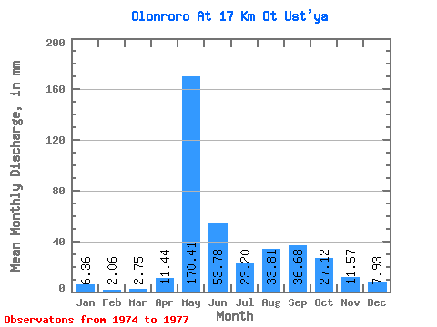
| Statistic | Jan | Feb | Mar | Apr | May | Jun | Jul | Aug | Sep | Oct | Nov | Dec | Annual |
|---|---|---|---|---|---|---|---|---|---|---|---|---|---|
| Mean | 6.36 | 2.08 | 2.76 | 11.45 | 170.39 | 53.78 | 23.21 | 33.81 | 36.69 | 27.11 | 11.56 | 7.92 | 341.41 |
| Standard Deviation | 3.50 | 2.17 | 3.04 | 11.86 | 26.70 | 20.09 | 7.02 | 18.58 | 14.97 | 12.49 | 1.31 | 1.39 | 83.45 |
| Min | 4.02 | 0.61 | 0.00 | 1.62 | 139.59 | 38.23 | 17.74 | 22.09 | 22.68 | 16.74 | 10.37 | 6.36 | 282.40 |
| Max | 10.38 | 4.58 | 6.03 | 24.62 | 186.79 | 76.46 | 31.13 | 55.23 | 57.67 | 44.86 | 12.96 | 9.04 | 400.42 |
| Coefficient of Variation | 0.55 | 1.04 | 1.10 | 1.04 | 0.16 | 0.37 | 0.30 | 0.55 | 0.41 | 0.46 | 0.11 | 0.18 | 0.24 |
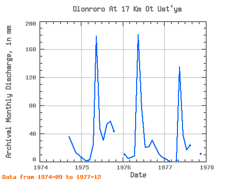
| Year | Jan | Feb | Mar | Apr | May | Jun | Jul | Aug | Sep | Oct | Nov | Dec | Annual | 1974 | 35.64 | 26.45 | 12.96 | 9.04 | 1975 | 4.69 | 1.07 | 2.24 | 24.62 | 184.80 | 46.66 | 31.13 | 55.23 | 57.67 | 44.86 | 1976 | 10.38 | 4.58 | 6.03 | 8.10 | 186.79 | 76.46 | 20.75 | 22.09 | 30.78 | 20.42 | 10.37 | 6.36 | 400.42 | 1977 | 4.02 | 0.61 | 0.00 | 1.62 | 139.59 | 38.23 | 17.74 | 24.10 | 22.68 | 16.74 | 11.34 | 8.37 | 282.40 |
|---|
 Return to R-Arctic Net Home Page