|
|
|||||||||||||||||
| Point ID: 7985 | Downloads | Plots | Site Data | Code: 3631 |
|
|
|||||||||||||||||
| Download | |
|---|---|
| Site Descriptor Information | Site Time Series Data |
| Link to all available data | |
|
|
| View: | Statistics | Time Series |
| Units: | m3/s |
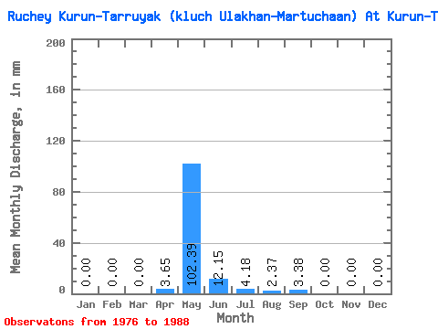
| Statistic | Jan | Feb | Mar | Apr | May | Jun | Jul | Aug | Sep | Oct | Nov | Dec | Annual |
|---|---|---|---|---|---|---|---|---|---|---|---|---|---|
| Mean | 0.00 | 0.00 | 0.00 | 3.71 | 102.33 | 12.21 | 4.24 | 2.31 | 3.41 | 0.01 | 0.00 | 0.00 | 122.63 |
| Standard Deviation | 0.00 | 0.00 | 0.00 | 7.03 | 22.27 | 11.46 | 7.78 | 7.03 | 9.37 | 0.04 | 0.00 | 0.00 | 24.50 |
| Min | 0.00 | 0.00 | 0.00 | 0.00 | 59.98 | 0.00 | 0.00 | 0.00 | 0.00 | 0.00 | 0.00 | 0.00 | 67.81 |
| Max | 0.00 | 0.00 | 0.00 | 21.60 | 129.72 | 37.80 | 25.11 | 22.32 | 28.35 | 0.14 | 0.00 | 0.00 | 146.57 |
| Coefficient of Variation | 1.89 | 0.22 | 0.94 | 1.84 | 3.04 | 2.75 | 3.16 | 0.20 |
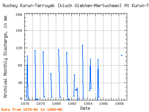
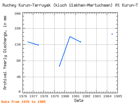
| Year | Jan | Feb | Mar | Apr | May | Jun | Jul | Aug | Sep | Oct | Nov | Dec | Annual | 1976 | 0.00 | 0.00 | 0.00 | 6.21 | 106.00 | 13.50 | 2.65 | 0.00 | 0.00 | 0.00 | 0.00 | 0.00 | 126.71 | 1977 | 0.00 | 0.00 | 0.00 | 0.00 | 117.16 | 1.08 | 1.53 | 0.00 | 1.48 | 0.00 | 0.00 | 0.00 | 119.17 | 1978 | 0.00 | 0.00 | 0.00 | 0.00 | 114.46 | 9.31 | 7.25 | 0.00 | 0.00 | 0.00 | 0.00 | 1979 | 0.00 | 0.00 | 0.00 | 0.00 | 62.77 | 6.08 | 0.00 | 0.00 | 0.00 | 0.00 | 0.00 | 0.00 | 67.81 | 1980 | 0.00 | 0.00 | 0.00 | 0.00 | 119.95 | 16.20 | 5.72 | 0.00 | 0.00 | 0.00 | 0.00 | 0.00 | 139.86 | 1981 | 0.00 | 0.00 | 0.00 | 0.00 | 112.98 | 12.96 | 0.14 | 0.84 | 0.81 | 0.00 | 0.00 | 0.00 | 125.88 | 1982 | 0.00 | 0.00 | 0.00 | 8.78 | 59.98 | 0.00 | 25.11 | 22.32 | 28.35 | 0.14 | 0.00 | 0.00 | 143.28 | 1983 | 0.00 | 0.00 | 0.00 | 0.00 | 129.72 | 3.92 | 0.00 | 0.00 | 0.00 | 0.00 | 0.00 | 0.00 | 131.36 | 1984 | 0.00 | 0.00 | 0.00 | 21.60 | 99.03 | 27.00 | 0.00 | 0.00 | 0.00 | 0.00 | 0.00 | 0.00 | 146.57 | 1985 | 0.00 | 0.00 | 0.00 | 0.54 | 97.64 | 6.48 | 0.00 | 0.00 | 0.00 | 0.00 | 0.00 | 0.00 | 103.01 | 1988 | 106.00 | 37.80 |
|---|
 Return to R-Arctic Net Home Page