|
|
|||||||||||||||||
| Point ID: 7980 | Downloads | Plots | Site Data | Code: 3623 |
|
|
|||||||||||||||||
| Download | |
|---|---|
| Site Descriptor Information | Site Time Series Data |
| Link to all available data | |
|
|
| View: | Statistics | Time Series |
| Units: | m3/s |
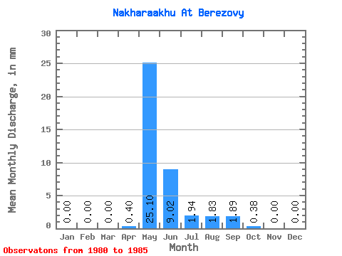
| Statistic | Jan | Feb | Mar | Apr | May | Jun | Jul | Aug | Sep | Oct | Nov | Dec | Annual |
|---|---|---|---|---|---|---|---|---|---|---|---|---|---|
| Mean | 0.00 | 0.00 | 0.00 | 0.40 | 25.09 | 9.02 | 1.94 | 1.84 | 1.89 | 0.39 | 0.00 | 0.00 | 40.66 |
| Standard Deviation | 0.00 | 0.00 | 0.00 | 0.90 | 13.36 | 5.22 | 3.17 | 3.85 | 2.52 | 0.58 | 0.00 | 0.00 | 17.37 |
| Min | 0.00 | 0.00 | 0.00 | 0.00 | 8.43 | 3.44 | 0.22 | 0.00 | 0.00 | 0.00 | 0.00 | 0.00 | 12.23 |
| Max | 0.00 | 0.00 | 0.00 | 2.00 | 43.05 | 14.61 | 7.55 | 8.73 | 5.44 | 1.33 | 0.00 | 0.00 | 57.40 |
| Coefficient of Variation | 2.24 | 0.53 | 0.58 | 1.63 | 2.10 | 1.33 | 1.52 | 0.43 |
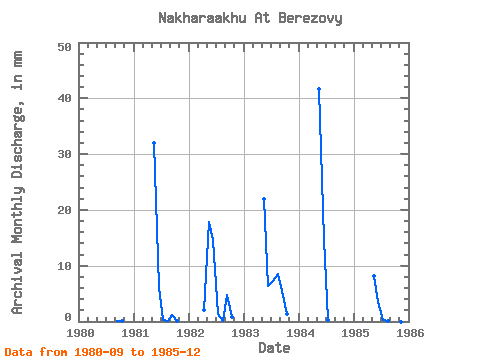
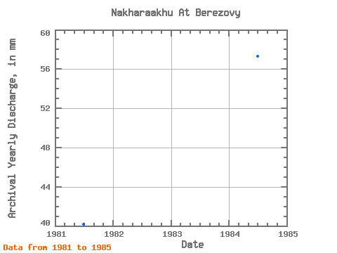
| Year | Jan | Feb | Mar | Apr | May | Jun | Jul | Aug | Sep | Oct | Nov | Dec | Annual | 1980 | 0.01 | 0.03 | 0.00 | 0.00 | 1981 | 0.00 | 0.00 | 0.00 | 0.00 | 32.99 | 6.16 | 0.22 | 0.16 | 1.13 | 0.04 | 0.00 | 0.00 | 40.22 | 1982 | 0.00 | 0.00 | 0.00 | 2.00 | 18.35 | 14.61 | 1.36 | 0.13 | 4.73 | 0.90 | 0.00 | 0.00 | 42.02 | 1983 | 0.00 | 0.00 | 0.00 | 0.00 | 22.64 | 6.30 | 7.55 | 8.73 | 5.44 | 1.33 | 0.00 | 0.00 | 51.44 | 1984 | 0.00 | 0.00 | 0.00 | 0.00 | 43.05 | 14.61 | 0.30 | 0.00 | 0.00 | 0.00 | 0.00 | 0.00 | 57.40 | 1985 | 0.00 | 0.00 | 0.00 | 0.00 | 8.43 | 3.44 | 0.28 | 0.16 | 0.03 | 0.00 | 0.00 | 0.00 | 12.23 |
|---|
 Return to R-Arctic Net Home Page