|
|
|||||||||||||||||
| Point ID: 7977 | Downloads | Plots | Site Data | Code: 3619 |
|
|
|||||||||||||||||
| Download | |
|---|---|
| Site Descriptor Information | Site Time Series Data |
| Link to all available data | |
|
|
| View: | Statistics | Time Series |
| Units: | m3/s |
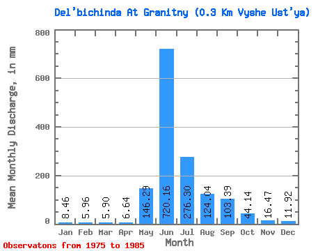
| Statistic | Jan | Feb | Mar | Apr | May | Jun | Jul | Aug | Sep | Oct | Nov | Dec | Annual |
|---|---|---|---|---|---|---|---|---|---|---|---|---|---|
| Mean | 8.46 | 6.01 | 5.89 | 6.64 | 146.26 | 720.16 | 276.27 | 124.03 | 103.39 | 44.13 | 16.46 | 11.92 | 1481.82 |
| Standard Deviation | 2.40 | 1.89 | 1.69 | 3.42 | 99.71 | 146.22 | 168.82 | 45.56 | 44.71 | 17.70 | 5.41 | 4.23 | 307.97 |
| Min | 5.39 | 3.73 | 3.53 | 3.24 | 32.36 | 484.20 | 97.26 | 58.21 | 28.80 | 13.58 | 8.82 | 7.07 | 1162.31 |
| Max | 12.65 | 10.34 | 9.11 | 14.04 | 340.33 | 943.20 | 665.78 | 175.74 | 178.92 | 72.34 | 25.74 | 21.39 | 2116.78 |
| Coefficient of Variation | 0.28 | 0.31 | 0.29 | 0.52 | 0.68 | 0.20 | 0.61 | 0.37 | 0.43 | 0.40 | 0.33 | 0.35 | 0.21 |
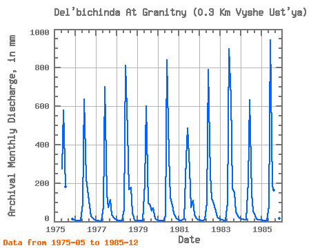
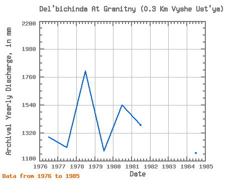
| Year | Jan | Feb | Mar | Apr | May | Jun | Jul | Aug | Sep | Oct | Nov | Dec | Annual | 1975 | 284.54 | 579.60 | 185.97 | 12.06 | 8.18 | 1976 | 5.95 | 4.74 | 5.02 | 4.32 | 94.29 | 637.20 | 230.61 | 169.42 | 80.46 | 28.08 | 15.12 | 10.41 | 1287.06 | 1977 | 5.39 | 3.73 | 3.53 | 3.42 | 80.34 | 702.00 | 146.73 | 75.88 | 111.78 | 35.15 | 18.72 | 12.83 | 1205.60 | 1978 | 9.86 | 6.61 | 4.83 | 6.84 | 66.02 | 813.60 | 487.25 | 172.21 | 178.92 | 44.63 | 8.82 | 7.07 | 1807.76 | 1979 | 6.88 | 5.08 | 5.02 | 3.60 | 206.43 | 601.20 | 97.26 | 95.40 | 56.52 | 72.34 | 16.92 | 10.79 | 1178.93 | 1980 | 6.14 | 5.42 | 4.65 | 3.24 | 32.36 | 840.60 | 353.35 | 126.65 | 84.96 | 47.61 | 18.72 | 14.32 | 1541.84 | 1981 | 8.18 | 5.59 | 7.81 | 14.04 | 340.33 | 484.20 | 280.82 | 76.44 | 109.98 | 36.45 | 14.58 | 10.41 | 1384.77 | 1982 | 8.93 | 4.74 | 5.95 | 7.56 | 102.47 | 792.00 | 249.20 | 122.93 | 93.06 | 69.37 | 23.76 | 16.92 | 1500.38 | 1983 | 11.16 | 7.79 | 7.25 | 6.66 | 102.47 | 896.40 | 665.78 | 175.74 | 147.96 | 50.58 | 25.74 | 21.39 | 2116.78 | 1984 | 12.65 | 10.34 | 9.11 | 10.26 | 215.73 | 631.80 | 150.45 | 58.21 | 28.80 | 13.58 | 8.82 | 10.23 | 1162.31 | 1985 | 9.48 | 6.10 | 5.76 | 6.48 | 83.87 | 943.20 | 191.55 | 167.38 | 141.48 | 43.52 | 17.82 | 8.55 | 1632.79 |
|---|
 Return to R-Arctic Net Home Page