|
|
|||||||||||||||||
| Point ID: 7975 | Downloads | Plots | Site Data | Code: 3616 |
|
|
|||||||||||||||||
| Download | |
|---|---|
| Site Descriptor Information | Site Time Series Data |
| Link to all available data | |
|
|
| View: | Statistics | Time Series |
| Units: | m3/s |
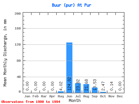
| Statistic | Jan | Feb | Mar | Apr | May | Jun | Jul | Aug | Sep | Oct | Nov | Dec | Annual |
|---|---|---|---|---|---|---|---|---|---|---|---|---|---|
| Mean | 0.00 | 0.00 | 0.00 | 0.00 | 4.02 | 124.82 | 23.81 | 21.67 | 13.53 | 2.47 | 0.14 | 0.00 | 163.01 |
| Standard Deviation | 0.00 | 0.00 | 0.00 | 0.00 | 6.87 | 38.75 | 20.39 | 19.30 | 10.30 | 2.35 | 0.13 | 0.00 | 39.85 |
| Min | 0.00 | 0.00 | 0.00 | 0.00 | 0.00 | 51.65 | 4.18 | 2.81 | 2.82 | 0.46 | 0.00 | 0.00 | 122.53 |
| Max | 0.00 | 0.00 | 0.00 | 0.00 | 19.14 | 186.17 | 81.32 | 69.20 | 39.16 | 7.84 | 0.42 | 0.00 | 215.95 |
| Coefficient of Variation | 1.71 | 0.31 | 0.86 | 0.89 | 0.76 | 0.95 | 0.97 | 0.24 |
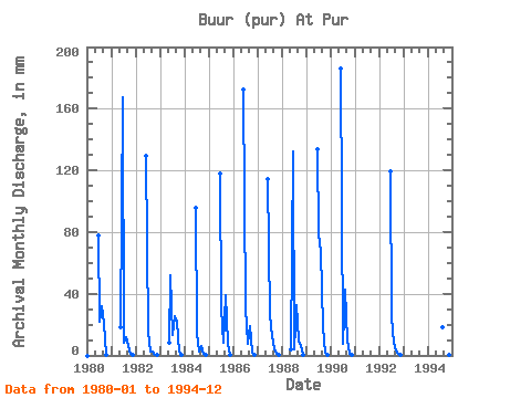
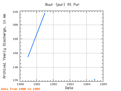
| Year | Jan | Feb | Mar | Apr | May | Jun | Jul | Aug | Sep | Oct | Nov | Dec | Annual | 1980 | 0.00 | 0.00 | 0.00 | 0.00 | 0.00 | 77.95 | 22.48 | 33.03 | 20.24 | 0.46 | 0.00 | 0.00 | 154.60 | 1981 | 0.00 | 0.00 | 0.00 | 0.00 | 19.14 | 167.06 | 8.33 | 12.39 | 6.32 | 0.87 | 0.02 | 0.00 | 215.95 | 1982 | 0.00 | 0.00 | 0.00 | 0.00 | 0.00 | 129.22 | 16.05 | 2.91 | 2.82 | 0.48 | 0.01 | 0.00 | 153.08 | 1983 | 0.00 | 0.00 | 0.00 | 0.00 | 8.60 | 51.65 | 14.05 | 26.00 | 21.95 | 2.68 | 0.15 | 0.00 | 125.24 | 1984 | 0.00 | 0.00 | 0.00 | 0.00 | 0.00 | 95.92 | 15.25 | 2.81 | 6.09 | 1.23 | 0.07 | 0.00 | 122.53 | 1985 | 0.00 | 0.00 | 0.00 | 0.00 | 0.00 | 117.68 | 31.47 | 8.64 | 39.16 | 7.84 | 0.42 | 0.00 | 206.66 | 1986 | 172.17 | 32.45 | 7.68 | 18.67 | 2.21 | 0.18 | 1987 | 114.46 | 27.17 | 13.10 | 3.88 | 1.30 | 0.08 | 1988 | 4.42 | 132.44 | 4.18 | 33.62 | 9.99 | 6.25 | 0.25 | 1989 | 133.76 | 81.32 | 69.20 | 18.50 | 1.71 | 0.04 | 1990 | 0.00 | 186.17 | 7.58 | 44.37 | 9.50 | 1.18 | 0.04 | 1992 | 119.38 | 25.41 | 8.88 | 3.46 | 1.08 | 0.19 | 1994 | 0.00 | 0.00 | 0.00 | 0.00 | 19.12 | 15.29 | 4.85 | 0.35 | 0.00 |
|---|
 Return to R-Arctic Net Home Page