|
|
|||||||||||||||||
| Point ID: 7974 | Downloads | Plots | Site Data | Code: 3615 |
|
|
|||||||||||||||||
| Download | |
|---|---|
| Site Descriptor Information | Site Time Series Data |
| Link to all available data | |
|
|
| View: | Statistics | Time Series |
| Units: | m3/s |
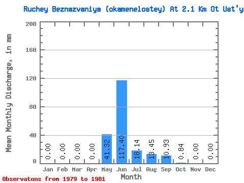
| Statistic | Jan | Feb | Mar | Apr | May | Jun | Jul | Aug | Sep | Oct | Nov | Dec | Annual |
|---|---|---|---|---|---|---|---|---|---|---|---|---|---|
| Mean | 0.00 | 0.00 | 0.00 | 0.00 | 41.27 | 117.40 | 18.17 | 13.45 | 10.93 | 0.84 | 0.00 | 0.00 | 202.62 |
| Standard Deviation | 0.00 | 0.00 | 0.00 | 0.00 | 45.81 | 94.49 | 16.30 | 11.43 | 4.24 | 0.84 | 0.00 | 0.00 | 73.86 |
| Min | 0.00 | 0.00 | 0.00 | 0.00 | 1.32 | 27.90 | 4.08 | 0.72 | 6.62 | 0.24 | 0.00 | 0.00 | 144.24 |
| Max | 0.00 | 0.00 | 0.00 | 0.00 | 91.27 | 216.19 | 36.03 | 22.82 | 15.11 | 1.80 | 0.00 | 0.00 | 285.64 |
| Coefficient of Variation | 1.11 | 0.81 | 0.90 | 0.85 | 0.39 | 1.00 | 0.36 |
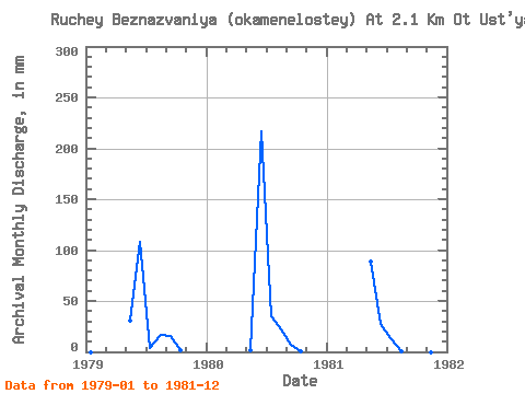
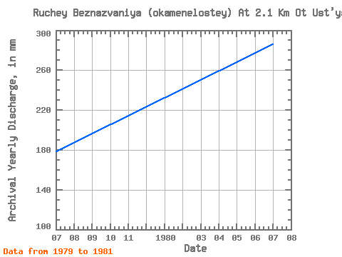
| Year | Jan | Feb | Mar | Apr | May | Jun | Jul | Aug | Sep | Oct | Nov | Dec | Annual | 1979 | 0.00 | 0.00 | 0.00 | 0.00 | 31.22 | 108.10 | 4.08 | 16.81 | 15.11 | 1.80 | 0.00 | 0.00 | 177.97 | 1980 | 0.00 | 0.00 | 0.00 | 0.00 | 1.32 | 216.19 | 36.03 | 22.82 | 6.62 | 0.48 | 0.00 | 0.00 | 285.64 | 1981 | 0.00 | 0.00 | 0.00 | 0.00 | 91.27 | 27.90 | 14.41 | 0.72 | 11.04 | 0.24 | 0.00 | 0.00 | 144.24 |
|---|
 Return to R-Arctic Net Home Page