|
|
|||||||||||||||||
| Point ID: 7972 | Downloads | Plots | Site Data | Code: 3613 |
|
|
|||||||||||||||||
| Download | |
|---|---|
| Site Descriptor Information | Site Time Series Data |
| Link to all available data | |
|
|
| View: | Statistics | Time Series |
| Units: | m3/s |
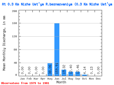
| Statistic | Jan | Feb | Mar | Apr | May | Jun | Jul | Aug | Sep | Oct | Nov | Dec | Annual |
|---|---|---|---|---|---|---|---|---|---|---|---|---|---|
| Mean | 0.00 | 0.00 | 0.00 | 0.00 | 38.05 | 159.91 | 19.32 | 12.40 | 12.46 | 4.13 | 0.13 | 0.00 | 247.61 |
| Standard Deviation | 0.00 | 0.00 | 0.00 | 0.00 | 65.90 | 108.58 | 18.87 | 11.86 | 7.37 | 3.39 | 0.08 | 0.00 | 76.37 |
| Min | 0.00 | 0.00 | 0.00 | 0.00 | 0.00 | 50.56 | 6.15 | 0.43 | 6.27 | 1.76 | 0.04 | 0.00 | 186.94 |
| Max | 0.00 | 0.00 | 0.00 | 0.00 | 114.14 | 267.70 | 40.94 | 24.15 | 20.61 | 8.01 | 0.19 | 0.00 | 333.36 |
| Coefficient of Variation | 1.73 | 0.68 | 0.98 | 0.96 | 0.59 | 0.82 | 0.60 | 0.31 |
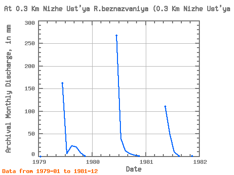
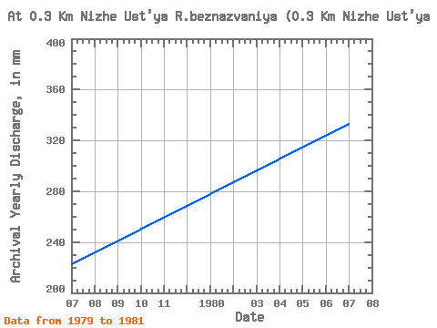
| Year | Jan | Feb | Mar | Apr | May | Jun | Jul | Aug | Sep | Oct | Nov | Dec | Annual | 1979 | 0.00 | 0.00 | 0.00 | 0.00 | 0.00 | 161.47 | 6.15 | 24.15 | 20.61 | 8.01 | 0.16 | 0.00 | 222.53 | 1980 | 0.00 | 0.00 | 0.00 | 0.00 | 0.00 | 267.70 | 40.94 | 12.62 | 6.27 | 2.63 | 0.19 | 0.00 | 333.36 | 1981 | 0.00 | 0.00 | 0.00 | 0.00 | 114.14 | 50.56 | 10.87 | 0.43 | 10.52 | 1.76 | 0.04 | 0.00 | 186.94 |
|---|
 Return to R-Arctic Net Home Page