|
|
|||||||||||||||||
| Point ID: 7970 | Downloads | Plots | Site Data | Code: 3611 |
|
|
|||||||||||||||||
| Download | |
|---|---|
| Site Descriptor Information | Site Time Series Data |
| Link to all available data | |
|
|
| View: | Statistics | Time Series |
| Units: | m3/s |
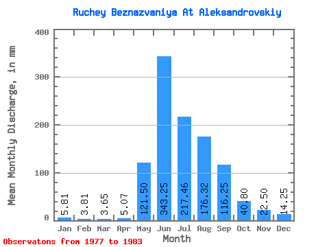
| Statistic | Jan | Feb | Mar | Apr | May | Jun | Jul | Aug | Sep | Oct | Nov | Dec | Annual |
|---|---|---|---|---|---|---|---|---|---|---|---|---|---|
| Mean | 5.80 | 3.83 | 3.67 | 5.02 | 121.49 | 343.22 | 217.47 | 176.25 | 116.28 | 40.85 | 22.46 | 14.20 | 1127.07 |
| Standard Deviation | 5.06 | 4.23 | 3.60 | 4.49 | 24.13 | 126.41 | 85.30 | 115.01 | 42.09 | 12.15 | 13.43 | 11.22 | 283.80 |
| Min | 0.34 | 0.31 | 0.00 | 0.00 | 94.58 | 105.89 | 109.40 | 58.12 | 43.02 | 22.79 | 8.05 | 1.03 | 719.73 |
| Max | 12.60 | 10.45 | 8.43 | 11.10 | 153.84 | 476.49 | 345.29 | 355.55 | 164.34 | 54.77 | 38.67 | 29.70 | 1414.40 |
| Coefficient of Variation | 0.87 | 1.10 | 0.98 | 0.90 | 0.20 | 0.37 | 0.39 | 0.65 | 0.36 | 0.30 | 0.60 | 0.79 | 0.25 |
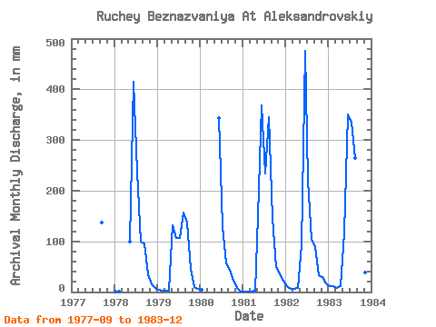
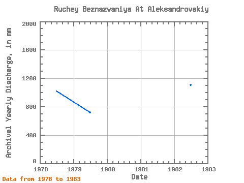
| Year | Jan | Feb | Mar | Apr | May | Jun | Jul | Aug | Sep | Oct | Nov | Dec | Annual | 1977 | 137.87 | 1978 | 1.59 | 0.31 | 0.00 | 0.00 | 102.56 | 414.79 | 245.01 | 102.56 | 95.96 | 35.33 | 14.34 | 7.52 | 1018.83 | 1979 | 5.13 | 2.28 | 1.94 | 2.98 | 135.61 | 105.89 | 109.40 | 161.82 | 136.77 | 46.72 | 9.71 | 5.93 | 719.73 | 1980 | 3.88 | 343.03 | 134.47 | 58.12 | 43.02 | 22.79 | 8.05 | 1.03 | 1981 | 0.34 | 0.62 | 1.48 | 2.87 | 153.84 | 368.39 | 241.59 | 355.55 | 146.70 | 51.28 | 35.30 | 23.93 | 1375.21 | 1982 | 11.28 | 5.50 | 6.50 | 8.16 | 94.58 | 476.49 | 229.05 | 105.98 | 89.34 | 34.19 | 28.68 | 17.09 | 1107.17 | 1983 | 12.60 | 10.45 | 8.43 | 11.10 | 120.86 | 350.75 | 345.29 | 273.50 | 164.34 | 54.77 | 38.67 | 29.70 | 1414.40 |
|---|
 Return to R-Arctic Net Home Page