|
|
|||||||||||||||||
| Point ID: 7955 | Downloads | Plots | Site Data | Code: 3593 |
|
|
|||||||||||||||||
| Download | |
|---|---|
| Site Descriptor Information | Site Time Series Data |
| Link to all available data | |
|
|
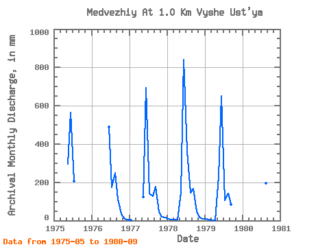
| View: | Statistics | Time Series |
| Units: | m3/s |
| Statistic | Jan | Feb | Mar | Apr | May | Jun | Jul | Aug | Sep | Oct | Nov | Dec | Annual |
|---|---|---|---|---|---|---|---|---|---|---|---|---|---|
| Mean | 7.63 | 5.88 | 2.54 | 2.98 | 204.59 | 677.10 | 231.23 | 177.75 | 136.84 | 44.00 | 16.37 | 10.95 | 1789.44 |
| Standard Deviation | 3.60 | 0.38 | 2.37 | 3.41 | 82.39 | 140.04 | 113.56 | 52.25 | 37.79 | 7.76 | 5.55 | 4.41 | |
| Min | 3.52 | 5.61 | 0.00 | 0.57 | 126.13 | 488.31 | 108.53 | 131.99 | 85.17 | 35.20 | 10.22 | 6.75 | 1789.44 |
| Max | 10.27 | 6.15 | 4.69 | 5.39 | 305.05 | 840.34 | 375.45 | 258.12 | 176.02 | 49.86 | 21.01 | 15.55 | 1789.44 |
| Coefficient of Variation | 0.47 | 0.06 | 0.93 | 1.15 | 0.40 | 0.21 | 0.49 | 0.29 | 0.28 | 0.18 | 0.34 | 0.40 |
| Year | Jan | Feb | Mar | Apr | May | Jun | Jul | Aug | Sep | Oct | Nov | Dec | Annual | 1975 | 305.05 | 564.96 | 211.19 | 1976 | 488.31 | 178.92 | 258.12 | 113.56 | 35.20 | 10.22 | 6.75 | 1977 | 3.52 | 0.00 | 126.13 | 692.71 | 146.66 | 131.99 | 176.02 | 46.93 | 21.01 | 15.55 | 1978 | 10.27 | 6.15 | 4.69 | 5.39 | 149.59 | 840.34 | 375.45 | 149.59 | 167.50 | 49.86 | 17.89 | 10.56 | 1789.44 | 1979 | 9.09 | 5.61 | 2.93 | 0.57 | 237.59 | 650.13 | 108.53 | 146.66 | 85.17 | 1980 | 826.15 | 366.65 | 202.39 | 141.95 |
|---|
 Return to R-Arctic Net Home Page
