|
|
|||||||||||||||||
| Point ID: 7949 | Downloads | Plots | Site Data | Code: 3585 |
|
|
|||||||||||||||||
| Download | |
|---|---|
| Site Descriptor Information | Site Time Series Data |
| Link to all available data | |
|
|
| View: | Statistics | Time Series |
| Units: | m3/s |
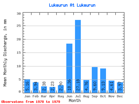
| Statistic | Jan | Feb | Mar | Apr | May | Jun | Jul | Aug | Sep | Oct | Nov | Dec | Annual |
|---|---|---|---|---|---|---|---|---|---|---|---|---|---|
| Mean | 5.16 | 3.98 | 2.38 | 2.23 | 2.90 | 18.34 | 27.18 | 4.76 | 9.60 | 9.12 | 4.61 | 3.97 | 66.08 |
| Standard Deviation | 21.32 | 26.65 | 0.56 | 7.60 | |||||||||
| Min | 5.16 | 3.98 | 2.38 | 2.23 | 2.90 | 3.26 | 8.33 | 4.36 | 4.22 | 9.12 | 4.61 | 3.97 | 66.08 |
| Max | 5.16 | 3.98 | 2.38 | 2.23 | 2.90 | 33.41 | 46.02 | 5.16 | 14.98 | 9.12 | 4.61 | 3.97 | 66.08 |
| Coefficient of Variation | 1.16 | 0.98 | 0.12 | 0.79 |
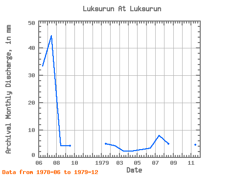
| Year | Jan | Feb | Mar | Apr | May | Jun | Jul | Aug | Sep | Oct | Nov | Dec | Annual | 1978 | 33.41 | 46.02 | 4.36 | 4.22 | 1979 | 5.16 | 3.98 | 2.38 | 2.23 | 2.90 | 3.26 | 8.33 | 5.16 | 14.98 | 9.12 | 4.61 | 3.97 | 66.08 |
|---|
 Return to R-Arctic Net Home Page