|
|
|||||||||||||||||
| Point ID: 7948 | Downloads | Plots | Site Data | Code: 3584 |
|
|
|||||||||||||||||
| Download | |
|---|---|
| Site Descriptor Information | Site Time Series Data |
| Link to all available data | |
|
|
| View: | Statistics | Time Series |
| Units: | m3/s |
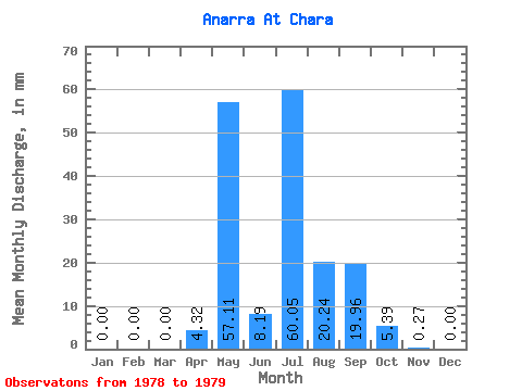
| Statistic | Jan | Feb | Mar | Apr | May | Jun | Jul | Aug | Sep | Oct | Nov | Dec | Annual |
|---|---|---|---|---|---|---|---|---|---|---|---|---|---|
| Mean | 0.00 | 0.00 | 0.00 | 4.32 | 57.10 | 8.19 | 60.03 | 20.24 | 19.96 | 5.39 | 0.27 | 0.00 | 163.33 |
| Standard Deviation | 0.00 | 0.00 | 0.00 | 67.05 | 22.53 | 23.81 | 5.01 | 0.38 | 0.00 | ||||
| Min | 0.00 | 0.00 | 0.00 | 4.32 | 57.10 | 8.19 | 12.62 | 4.31 | 3.13 | 1.85 | 0.00 | 0.00 | 163.33 |
| Max | 0.00 | 0.00 | 0.00 | 4.32 | 57.10 | 8.19 | 107.44 | 36.17 | 36.79 | 8.93 | 0.54 | 0.00 | 163.33 |
| Coefficient of Variation | 1.12 | 1.11 | 1.19 | 0.93 | 1.41 |
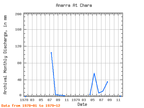
| Year | Jan | Feb | Mar | Apr | May | Jun | Jul | Aug | Sep | Oct | Nov | Dec | Annual | 1978 | 0.00 | 0.00 | 0.00 | 107.44 | 4.31 | 3.13 | 1.85 | 0.00 | 0.00 | 1979 | 0.00 | 0.00 | 0.00 | 4.32 | 57.10 | 8.19 | 12.62 | 36.17 | 36.79 | 8.93 | 0.54 | 0.00 | 163.33 |
|---|
 Return to R-Arctic Net Home Page