|
|
|||||||||||||||||
| Point ID: 7927 | Downloads | Plots | Site Data | Code: 3513 |
|
|
|||||||||||||||||
| Download | |
|---|---|
| Site Descriptor Information | Site Time Series Data |
| Link to all available data | |
|
|
| View: | Statistics | Time Series |
| Units: | m3/s |
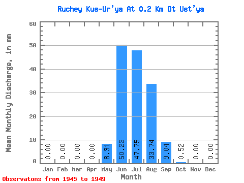
| Statistic | Jan | Feb | Mar | Apr | May | Jun | Jul | Aug | Sep | Oct | Nov | Dec | Annual |
|---|---|---|---|---|---|---|---|---|---|---|---|---|---|
| Mean | 0.00 | 0.00 | 0.00 | 0.00 | 8.30 | 50.33 | 47.64 | 33.94 | 8.94 | 0.41 | 0.00 | 0.00 | 148.83 |
| Standard Deviation | 0.00 | 0.00 | 0.00 | 0.00 | 6.65 | 20.66 | 14.32 | 21.17 | 7.69 | 0.93 | 0.00 | 0.00 | 34.73 |
| Min | 0.00 | 0.00 | 0.00 | 0.00 | 0.52 | 23.61 | 32.18 | 11.94 | 2.01 | 0.00 | 0.00 | 0.00 | 111.62 |
| Max | 0.00 | 0.00 | 0.00 | 0.00 | 17.65 | 80.37 | 67.47 | 67.47 | 22.10 | 2.08 | 0.00 | 0.00 | 183.49 |
| Coefficient of Variation | 0.80 | 0.41 | 0.30 | 0.62 | 0.86 | 2.24 | 0.23 |
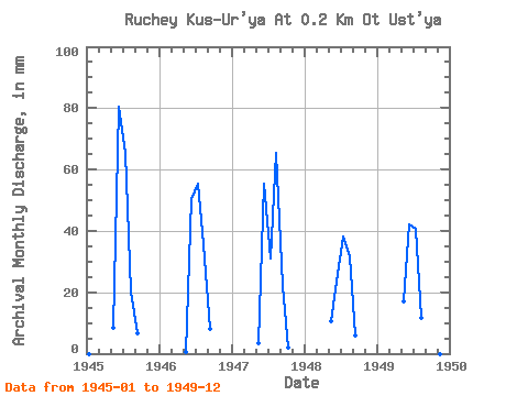
| Year | Jan | Feb | Mar | Apr | May | Jun | Jul | Aug | Sep | Oct | Nov | Dec | Annual | 1945 | 0.00 | 0.00 | 0.00 | 0.00 | 8.82 | 80.37 | 67.47 | 20.76 | 6.53 | 0.00 | 0.00 | 0.00 | 183.49 | 1946 | 0.00 | 0.00 | 0.00 | 0.00 | 0.52 | 50.23 | 57.09 | 36.85 | 8.04 | 0.00 | 0.00 | 0.00 | 151.89 | 1947 | 0.00 | 0.00 | 0.00 | 0.00 | 3.63 | 55.26 | 32.18 | 67.47 | 22.10 | 2.08 | 0.00 | 0.00 | 181.96 | 1948 | 0.00 | 0.00 | 0.00 | 0.00 | 10.90 | 23.61 | 39.44 | 32.70 | 6.03 | 0.00 | 0.00 | 0.00 | 111.62 | 1949 | 0.00 | 0.00 | 0.00 | 0.00 | 17.65 | 42.20 | 42.04 | 11.94 | 2.01 | 0.00 | 0.00 | 0.00 | 115.19 |
|---|
 Return to R-Arctic Net Home Page