|
|
|||||||||||||||||
| Point ID: 7905 | Downloads | Plots | Site Data | Code: 3412 |
|
|
|||||||||||||||||
| Download | |
|---|---|
| Site Descriptor Information | Site Time Series Data |
| Link to all available data | |

|
|
| View: | Statistics | Time Series |
| Units: | m3/s |
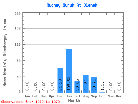
| Statistic | Jan | Feb | Mar | Apr | May | Jun | Jul | Aug | Sep | Oct | Nov | Dec | Annual |
|---|---|---|---|---|---|---|---|---|---|---|---|---|---|
| Mean | 0.00 | 0.00 | 0.00 | 0.00 | 61.36 | 109.45 | 30.09 | 44.80 | 39.64 | 1.35 | 0.02 | 0.00 | 286.42 |
| Standard Deviation | 0.00 | 0.00 | 0.00 | 0.00 | 52.90 | 85.22 | 42.22 | 79.98 | 44.69 | 1.15 | 0.06 | 0.00 | 172.78 |
| Min | 0.00 | 0.00 | 0.00 | 0.00 | 1.03 | 54.83 | 0.00 | 0.00 | 0.00 | 0.00 | 0.00 | 0.00 | 76.71 |
| Max | 0.00 | 0.00 | 0.00 | 0.00 | 149.45 | 294.19 | 108.32 | 223.27 | 106.34 | 2.75 | 0.17 | 0.00 | 545.79 |
| Coefficient of Variation | 0.86 | 0.78 | 1.40 | 1.79 | 1.13 | 0.85 | 2.65 | 0.60 |
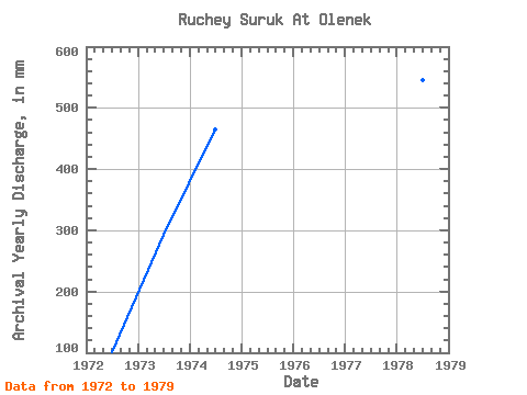
| Year | Jan | Feb | Mar | Apr | May | Jun | Jul | Aug | Sep | Oct | Nov | Dec | Annual | 1972 | 0.00 | 0.00 | 0.00 | 0.00 | 46.35 | 54.83 | 0.00 | 0.00 | 0.00 | 0.00 | 0.00 | 0.00 | 101.15 | 1973 | 0.00 | 0.00 | 0.00 | 0.00 | 60.08 | 69.78 | 108.32 | 25.75 | 28.25 | 2.75 | 0.00 | 0.00 | 292.77 | 1974 | 0.00 | 0.00 | 0.00 | 0.00 | 44.74 | 294.19 | 70.38 | 30.90 | 19.94 | 2.40 | 0.00 | 0.00 | 464.50 | 1975 | 0.00 | 0.00 | 0.00 | 0.00 | 113.30 | 96.37 | 8.93 | 2.75 | 23.26 | 0.52 | 0.00 | 0.00 | 244.62 | 1976 | 0.00 | 0.00 | 0.00 | 0.00 | 1.03 | 126.28 | 10.30 | 30.90 | 106.34 | 1.89 | 0.00 | 0.00 | 279.35 | 1978 | 0.00 | 0.00 | 0.00 | 0.00 | 149.45 | 63.24 | 12.70 | 223.27 | 99.69 | 1.89 | 0.17 | 0.00 | 545.79 | 1979 | 0.00 | 0.00 | 0.00 | 0.00 | 14.59 | 61.48 | 0.00 | 0.00 | 0.00 | 0.00 | 0.00 | 0.00 | 76.71 |
|---|
 Return to R-Arctic Net Home Page