|
|
|||||||||||||||||
| Point ID: 7896 | Downloads | Plots | Site Data | Code: 3385 |
|
|
|||||||||||||||||
| Download | |
|---|---|
| Site Descriptor Information | Site Time Series Data |
| Link to all available data | |
|
|
| View: | Statistics | Time Series |
| Units: | m3/s |
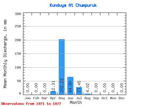
| Statistic | Jan | Feb | Mar | Apr | May | Jun | Jul | Aug | Sep | Oct | Nov | Dec | Annual |
|---|---|---|---|---|---|---|---|---|---|---|---|---|---|
| Mean | 0.00 | 0.00 | 0.00 | 12.31 | 202.19 | 65.02 | 27.23 | 3.79 | 0.00 | 0.00 | 0.00 | 0.00 | 286.01 |
| Standard Deviation | 0.00 | 0.00 | 0.00 | 27.53 | 163.54 | 68.24 | 46.00 | 6.57 | 0.00 | 0.00 | 0.00 | 0.00 | 151.44 |
| Min | 0.00 | 0.00 | 0.00 | 0.00 | 33.48 | 0.00 | 0.00 | 0.00 | 0.00 | 0.00 | 0.00 | 0.00 | 111.78 |
| Max | 0.00 | 0.00 | 0.00 | 61.56 | 461.95 | 136.08 | 80.34 | 11.38 | 0.00 | 0.00 | 0.00 | 0.00 | 385.95 |
| Coefficient of Variation | 2.24 | 0.81 | 1.05 | 1.69 | 1.73 | 0.53 |
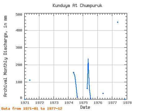
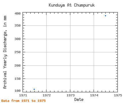
| Year | Jan | Feb | Mar | Apr | May | Jun | Jul | Aug | Sep | Oct | Nov | Dec | Annual | 1971 | 0.00 | 0.00 | 0.00 | 0.00 | 113.81 | 0.00 | 0.00 | 0.00 | 0.00 | 0.00 | 0.00 | 0.00 | 111.78 | 1974 | 0.00 | 0.00 | 0.00 | 0.00 | 160.68 | 136.08 | 80.34 | 11.38 | 0.00 | 0.00 | 0.00 | 0.00 | 385.95 | 1975 | 0.00 | 0.00 | 0.00 | 61.56 | 241.02 | 58.97 | 1.34 | 0.00 | 0.00 | 0.00 | 0.00 | 0.00 | 360.31 | 1976 | 0.00 | 0.00 | 0.00 | 0.00 | 33.48 | 0.00 | 0.00 | 0.00 | 0.00 | 1977 | 0.00 | 0.00 | 0.00 | 0.00 | 461.95 | 0.00 | 0.00 | 0.00 | 0.00 |
|---|
 Return to R-Arctic Net Home Page