|
|
|||||||||||||||||
| Point ID: 7887 | Downloads | Plots | Site Data | Code: 3371 |
|
|
|||||||||||||||||
| Download | |
|---|---|
| Site Descriptor Information | Site Time Series Data |
| Link to all available data | |
|
|
| View: | Statistics | Time Series |
| Units: | m3/s |
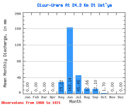
| Statistic | Jan | Feb | Mar | Apr | May | Jun | Jul | Aug | Sep | Oct | Nov | Dec | Annual |
|---|---|---|---|---|---|---|---|---|---|---|---|---|---|
| Mean | 0.00 | 0.00 | 0.00 | 0.00 | 29.21 | 163.18 | 45.45 | 12.66 | 12.08 | 1.75 | 0.02 | 0.00 | 265.31 |
| Standard Deviation | 0.00 | 0.00 | 0.00 | 0.00 | 33.97 | 83.24 | 14.89 | 14.07 | 11.96 | 1.90 | 0.04 | 0.00 | 58.05 |
| Min | 0.00 | 0.00 | 0.00 | 0.00 | 0.00 | 65.98 | 30.03 | 0.97 | 0.86 | 0.08 | 0.00 | 0.00 | 185.22 |
| Max | 0.00 | 0.00 | 0.00 | 0.00 | 63.30 | 245.06 | 64.92 | 29.21 | 23.56 | 4.46 | 0.08 | 0.00 | 314.40 |
| Coefficient of Variation | 1.16 | 0.51 | 0.33 | 1.11 | 0.99 | 1.09 | 2.00 | 0.22 |
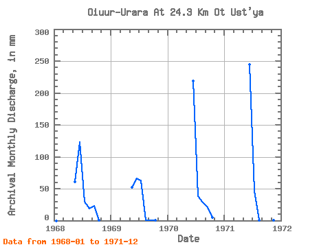
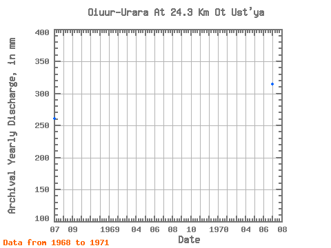
| Year | Jan | Feb | Mar | Apr | May | Jun | Jul | Aug | Sep | Oct | Nov | Dec | Annual | 1968 | 0.00 | 0.00 | 0.00 | 0.00 | 63.30 | 123.32 | 30.03 | 19.48 | 23.56 | 0.97 | 0.00 | 0.00 | 260.77 | 1969 | 0.00 | 0.00 | 0.00 | 0.00 | 53.56 | 65.98 | 64.92 | 0.97 | 0.86 | 0.08 | 0.00 | 0.00 | 185.22 | 1970 | 0.00 | 0.00 | 0.00 | 0.00 | 0.00 | 218.36 | 38.95 | 29.21 | 21.21 | 4.46 | 0.00 | 0.00 | 314.40 | 1971 | 0.00 | 0.00 | 0.00 | 0.00 | 0.00 | 245.06 | 47.88 | 0.97 | 2.67 | 1.46 | 0.08 | 0.00 | 300.86 |
|---|
 Return to R-Arctic Net Home Page