|
|
|||||||||||||||||
| Point ID: 7884 | Downloads | Plots | Site Data | Code: 3363 |
|
|
|||||||||||||||||
| Download | |
|---|---|
| Site Descriptor Information | Site Time Series Data |
| Link to all available data | |
|
|
| View: | Statistics | Time Series |
| Units: | m3/s |
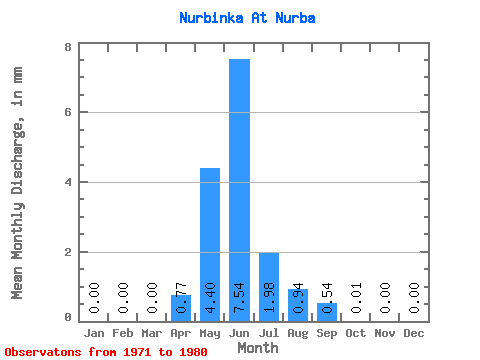
| Statistic | Jan | Feb | Mar | Apr | May | Jun | Jul | Aug | Sep | Oct | Nov | Dec | Annual |
|---|---|---|---|---|---|---|---|---|---|---|---|---|---|
| Mean | 0.00 | 0.00 | 0.00 | 0.77 | 4.40 | 7.54 | 1.98 | 0.94 | 0.54 | 0.01 | 0.00 | 0.00 | 16.19 |
| Standard Deviation | 0.00 | 0.00 | 0.00 | 1.86 | 6.69 | 4.08 | 2.41 | 1.21 | 0.61 | 0.01 | 0.00 | 0.00 | 10.74 |
| Min | 0.00 | 0.00 | 0.00 | 0.00 | 0.01 | 0.68 | 0.00 | 0.00 | 0.00 | 0.00 | 0.00 | 0.00 | 4.09 |
| Max | 0.00 | 0.00 | 0.00 | 4.57 | 16.46 | 13.09 | 6.03 | 2.67 | 1.32 | 0.03 | 0.00 | 0.00 | 30.78 |
| Coefficient of Variation | 2.42 | 1.52 | 0.54 | 1.22 | 1.28 | 1.12 | 1.56 | 0.66 |
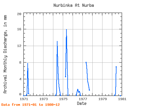
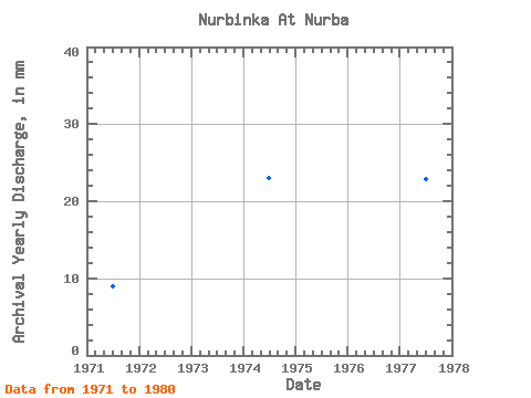
| Year | Jan | Feb | Mar | Apr | May | Jun | Jul | Aug | Sep | Oct | Nov | Dec | Annual | 1971 | 0.00 | 0.00 | 0.00 | 0.01 | 0.54 | 7.78 | 0.49 | 0.00 | 0.00 | 0.00 | 0.00 | 0.00 | 8.93 | 1974 | 0.00 | 0.00 | 0.00 | 0.01 | 0.65 | 13.09 | 6.03 | 2.23 | 0.89 | 0.02 | 0.00 | 0.00 | 22.97 | 1975 | 0.00 | 0.00 | 0.00 | 4.57 | 16.46 | 9.73 | 0.11 | 0.00 | 0.00 | 0.00 | 0.00 | 0.00 | 30.78 | 1976 | 0.00 | 0.00 | 0.00 | 0.00 | 0.01 | 0.68 | 1.57 | 0.76 | 1.05 | 0.03 | 0.00 | 0.00 | 4.09 | 1977 | 0.00 | 0.00 | 0.00 | 0.00 | 8.26 | 7.05 | 3.70 | 2.67 | 1.32 | 0.00 | 0.00 | 0.00 | 22.85 | 1980 | 0.00 | 0.00 | 0.00 | 0.03 | 0.48 | 6.94 | 0.00 | 0.00 | 0.00 | 0.00 | 0.00 | 0.00 | 7.54 |
|---|
 Return to R-Arctic Net Home Page